Lot #: 47556
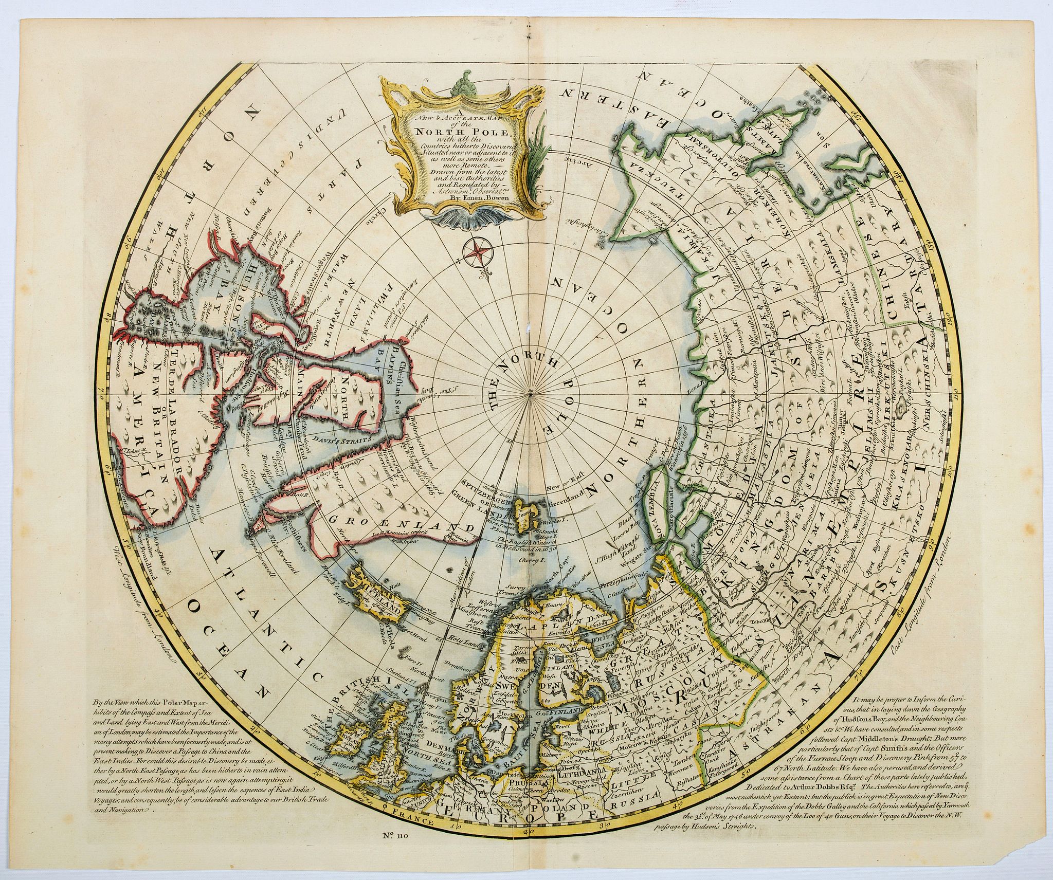
A NEW and Accurate Map of the North Pole, with all the Countries hitherto Discovered. . . |
||||||||||||||||||||
|
||||||||||||||||||||
|
|
||||||||||||||||||||
|
Selling price: $300
Sold in 2021 Join our News Letter to get informed when a similar item comes available. Do you have an example you would like to sell? |
Views: 272
|
|||||||||||||||||||
Description
A spectacular Arctic and sub-Arctic map, showing excellent detail around Hudson Bay area, Greenland, Spitzbergen & the Northeast Coast of Europe & Asia.
It depicts the Northeast passage, and shows the discoveries of Barentsz, Baffin, Hudson, Smith, Wager, James, and a host of other early explorers. The map appeared at the height of the so-called Dobbs-Middleton controversy and includes the following note: It may be proper to Inform the Curious, that in laying down the Geography of Hudson's Bay, and the Neighbouring Coasts &c We have consulted, and in some respects followed Capt. Middleton's Draught, But more particular that of Capt.Smith's and the Officer of the Furnance Sloop and Discovery Pink from 57 degrees to 67 North Latitude. ...
It depicts the Northeast passage, and shows the discoveries of Barentsz, Baffin, Hudson, Smith, Wager, James, and a host of other early explorers. The map appeared at the height of the so-called Dobbs-Middleton controversy and includes the following note: It may be proper to Inform the Curious, that in laying down the Geography of Hudson's Bay, and the Neighbouring Coasts &c We have consulted, and in some respects followed Capt. Middleton's Draught, But more particular that of Capt.Smith's and the Officer of the Furnance Sloop and Discovery Pink from 57 degrees to 67 North Latitude. ...
FAQ - Guarantee - Shipping
In our BUY-or-BID sale, you never pay more than the Buy price.
To buy or bid in this Buy-or-Bid sale you must register with us. It is free, and we automatically update you about future auctions.During the Buy-or-Bid sale, you can buy or bid on 600- 900 antique, rare maps, town views, old master prints, decorative prints, atlases, posters and Medieval manuscripts.
- We show the "Bid & Ask spread" (to define the gap between the minimum accepted bid and Buy price.)
- Items that have received bids within the BidAsk spread are sold at the highest bid at closing.
- Once the Buy price is paid, the sale for this item has closed.
Do you have a similar item you want to sell ?
Interested in selling your antique maps, original prints, vintage posters, or historic Ephemera?Let us help you!
Start your consignment today. We provide estimates free of charge from photographs sent via the Internet. Fill out our online estimation form, and we will contact you with an estimate.
Learn more about consigning at RarePaperSales.com
Guarantee
 We warranty the authenticity of each lot offered in our sale. There is no time limitation to this guarantee.
- Defects in lots have been carefully noted.
- If there are no remarks regarding splits, tears, discoloration, etc., there are no issues to be found for the item!
- All items are carefully and personally examined before being packed "in-house" and shipped by UPS, USPS, DHL or registered mail.
- We do not sell reproductions.
- A certificate of authenticity is provided for each acquired item and can be downloaded from your invoice page.
- Certificates can be found in the Invoice and Certificates center.
Shipping
Maps are shipped in solid tubes or flat between solid cardboard. Fully insured, signature required, and with online tracking. Shortly after shipment, you will get the tracking number by email.The standard is that we ship items by UPS or DHL for European destinations, and a flat shipping fee is added to each shipment. It is a one-time fee even if you buy multiple items. This fee covers shipping and insurance (up to the invoice amount) to:
- North America, Canada, Europe $ 30
- Asia $ 40
- For South America, Mauritius, Africa and Australia a shipping fee of $ 50 will be charged.
We charge only a one-time shipping fee if you have won 2 or more items.

Hold Shipment Service
Rare Paper Sales allows you to put your shipping on hold at no additional charge. This can be incredibly convenient for people who want to buy several items at different auctions and ship them together. The service is free, and you pay only one shipment fee.
Contact us if you want to use the Hold Service.
High-Resolution Digital Image Download |
|
|
RarePaperSales maintains an archive of most of our high-resolution rare maps, prints, posters and medieval manuscript scans. We make them freely available for download and study. Read more about free image download |
Click this image for a free HR-image download. |