Lot #: 99971
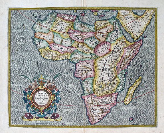
Africa ex magna orbis terre descriptione Gerardi Mercatories desumpta studio & industria G.M. Juniorius |
||||||||||||||||||||
|
||||||||||||||||||||
|
|
||||||||||||||||||||
|
Selling price: $1500
Sold in 2011 Join our News Letter to get informed when a similar item comes available. Do you have an example you would like to sell? |
Views: 146
|
|||||||||||||||||||
Description
A classic map of Africa. The map first appeared in Gerard Mercator’s Atlas sive Cosmographicae..., published posthumously in 1595. As stated in the title, this map is by Gerard Mercator's grandson, Gerard Mercator Jr. He extracted the information for this map from his famous grandfather's large world map of 1569. Mercator also used as sources the Waldseemuller and Gastaldi maps.
This fine, original color example is based on Gerard Mercator's famous 1569 World Map. This particular map has a high degree of accuracy especially along the coastline that was unsurpassed by any other 16th century cartographer (Klemp).
Much of the interior of Africa defers to the traditions of Ptolemeus.
The Nile river is shown with the two lakes and the Mountains of the Moon across southern Africa. Mercator does show European advance into the interior. For example, Mercator shows Portuguese exploration up the Cuama (Zambezi) River into the interior of south central Africa in the region of Monomotapa or Benamataxa, as he named it on his map. "Ca. Portogal" (the Portuguese Fort) is placed on the map within the junction of the Spirito and Cuama rivers (Betz).
Mercator tried to adhere to a more scientific approach and did not include the numerous beasts and mythical creature of other cartographers. The only figure within Africa is the seated legendary priest-king Prester John in Ethiopia. The cartouche is quite decorative with fruit and two satyrs.
The fine script is superb and the sea has Mercator's signature "miore" pattern.
Reference: Betz Map # 31. Tooley, p. 74-75 and Map #55. Norwich, map #21. Van der Krogt, Peter. Koeman's Atlantes Neerlandici, vol. 1. 't Goy-Houten: HES Publishers,1997, p. 711. Klemp, p. 24.
FAQ - Guarantee - Shipping
In our BUY-or-BID sale, you never pay more than the Buy price.
To buy or bid in this Buy-or-Bid sale you must register with us. It is free, and we automatically update you about future auctions.During the Buy-or-Bid sale, you can buy or bid on 600- 900 antique, rare maps, town views, old master prints, decorative prints, atlases, posters and Medieval manuscripts.
- We show the "Bid & Ask spread" (to define the gap between the minimum accepted bid and Buy price.)
- Items that have received bids within the BidAsk spread are sold at the highest bid at closing.
- Once the Buy price is paid, the sale for this item has closed.
Do you have a similar item you want to sell ?
Interested in selling your antique maps, original prints, vintage posters, or historic Ephemera?Let us help you!
Start your consignment today. We provide estimates free of charge from photographs sent via the Internet. Fill out our online estimation form, and we will contact you with an estimate.
Learn more about consigning at RarePaperSales.com
Guarantee
 We warranty the authenticity of each lot offered in our sale. There is no time limitation to this guarantee.
- Defects in lots have been carefully noted.
- If there are no remarks regarding splits, tears, discoloration, etc., there are no issues to be found for the item!
- All items are carefully and personally examined before being packed "in-house" and shipped by UPS, USPS, DHL or registered mail.
- We do not sell reproductions.
- A certificate of authenticity is provided for each acquired item and can be downloaded from your invoice page.
- Certificates can be found in the Invoice and Certificates center.
Shipping
Maps are shipped in solid tubes or flat between solid cardboard. Fully insured, signature required, and with online tracking. Shortly after shipment, you will get the tracking number by email.The standard is that we ship items by UPS or DHL for European destinations, and a flat shipping fee is added to each shipment. It is a one-time fee even if you buy multiple items. This fee covers shipping and insurance (up to the invoice amount) to:
- North America, Canada, Europe $ 30
- Asia $ 40
- For South America, Mauritius, Africa and Australia a shipping fee of $ 50 will be charged.
We charge only a one-time shipping fee if you have won 2 or more items.

Hold Shipment Service
Rare Paper Sales allows you to put your shipping on hold at no additional charge. This can be incredibly convenient for people who want to buy several items at different auctions and ship them together. The service is free, and you pay only one shipment fee.
Contact us if you want to use the Hold Service.
High-Resolution Digital Image Download |
|
|
RarePaperSales maintains an archive of most of our high-resolution rare maps, prints, posters and medieval manuscript scans. We make them freely available for download and study. Read more about free image download |
Click this image for a free HR-image download. |