Lot #: 44494
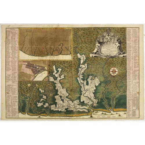
Algemene kaart van Suriname Algemeene kaart van de Colonie of Provintie van Suriname : met de rivieren, districten, ontdekkingen door militaire togten. . . |
||||||||||||||||||||
|
||||||||||||||||||||
|
|
||||||||||||||||||||
|
Selling price: $5500
Sold in 2023 Join our News Letter to get informed when a similar item comes available. Do you have an example you would like to sell? |
Views: 1031
Watchers:
10
|
|||||||||||||||||||
Description
Uncommon large scale map of of Suriname, indicating the different plantations and their owners. Consists of two glued-together sheets. Completed with funding by the Directeurs van de Societeit..
Complete title : Algemene kaart van Suriname Algemeene kaart van de Colonie of Provintie van Suriname : met de rivieren, districten, ontdekkingen door militaire togten en de grootte der gemeeten plantagien / door last, op kosten, en met approbatie der E.E. Heeren Directeurs van de Societeit, naar de naaukeurigste waarnemingen, door den ingenieur Alexander de Lavaux getekent ; in ’t koper gebragt door Hendrik de Leth, in de Visscher, te Amsterdam.
This large map is oriented with north at the bottom and depicts the colony extending inland along the watershed of the Suriname River, with hundreds of plantations lining the shores. Flanking the map are long tables identifying several hundred planters and in many cases the size of their holdings. The one town of any significant size is the capital of Paramaribo near the opening of the Suriname into the Atlantic Ocean. The lack of information about the vast outlying region beyond the rivers and plantations is obscured by liberal use of archaic "molehills" to represent mountains and other symbols for swamps and woodlands.
An inset at upper left locates Suriname in relation to the neighboring Dutch colony of Berbice. This map is of particular interest for its references to the "maroons," groups of escaped slaves who rebelled against the Dutch administration. Along the Marawini River two "rebel slave villages" are shown, as well as a third rebel village that had been burned to the ground. Further west (i.e., to the right) mapmaker Alexander de Lavaux indicates a route he took in pursuit of the rebels, which led him deep into the interior between the Surinam and Sarameca Rivers. A second inset provides a street plan of Paramaribo, giving street names and identifying government buildings, churches, the hospital and other landmarks. The large cartouche at upper right bears the arms of the three partners in the Society of Surinam, surmounted by those of the States General of the Netherlands.
This map is of particular interest record of one of the most important early Jewish communities in the Americas. Jews of primarily Portuguese and Spanish descent arrived in Suriname in waves in the mid-17th century, attracted by the official tolerance of the English and then the Dutch authorities. One researcher has identified no fewer than 70 Jewish-owned plantations on the map, the vast majority along the Surinam River in the vicinity of the settlements at "Joodsch Dorp" and "de Joode Savaane." (Richard Gottheil, "Contributions to the History of the Jews in Surinam") The latter was first settled in 1635 and was the first permanent Jewish settlement in the Americas. The inset plan of Paramaribo shows a "Joode Bree Straat" and both the "Portuguese" (i.e., Sephardic) and "German" (Ashkenazi) Synagogues, known respectively as Zedek ve Shalom and Neveh Shalom.
FAQ - Guarantee - Shipping
In our BUY-or-BID sale, you never pay more than the Buy price.
To buy or bid in this Buy-or-Bid sale you must register with us. It is free, and we automatically update you about future auctions.During the Buy-or-Bid sale, you can buy or bid on 600- 900 antique, rare maps, town views, old master prints, decorative prints, atlases, posters and Medieval manuscripts.
- We show the "Bid & Ask spread" (to define the gap between the minimum accepted bid and Buy price.)
- Items that have received bids within the BidAsk spread are sold at the highest bid at closing.
- Once the Buy price is paid, the sale for this item has closed.
Do you have a similar item you want to sell ?
Interested in selling your antique maps, original prints, vintage posters, or historic Ephemera?Let us help you!
Start your consignment today. We provide estimates free of charge from photographs sent via the Internet. Fill out our online estimation form, and we will contact you with an estimate.
Learn more about consigning at RarePaperSales.com
Guarantee
 We warranty the authenticity of each lot offered in our sale. There is no time limitation to this guarantee.
- Defects in lots have been carefully noted.
- If there are no remarks regarding splits, tears, discoloration, etc., there are no issues to be found for the item!
- All items are carefully and personally examined before being packed "in-house" and shipped by UPS, USPS, DHL or registered mail.
- We do not sell reproductions.
- A certificate of authenticity is provided for each acquired item and can be downloaded from your invoice page.
- Certificates can be found in the Invoice and Certificates center.
Shipping
Maps are shipped in solid tubes or flat between solid cardboard. Fully insured, signature required, and with online tracking. Shortly after shipment, you will get the tracking number by email.The standard is that we ship items by UPS or DHL for European destinations, and a flat shipping fee is added to each shipment. It is a one-time fee even if you buy multiple items. This fee covers shipping and insurance (up to the invoice amount) to:
- North America, Canada, Europe $ 30
- Asia $ 40
- For South America, Mauritius, Africa and Australia a shipping fee of $ 50 will be charged.
We charge only a one-time shipping fee if you have won 2 or more items.

Hold Shipment Service
Rare Paper Sales allows you to put your shipping on hold at no additional charge. This can be incredibly convenient for people who want to buy several items at different auctions and ship them together. The service is free, and you pay only one shipment fee.
Contact us if you want to use the Hold Service.
High-Resolution Digital Image Download |
|
|
RarePaperSales maintains an archive of most of our high-resolution rare maps, prints, posters and medieval manuscript scans. We make them freely available for download and study. Read more about free image download |

