Lot #: 14428
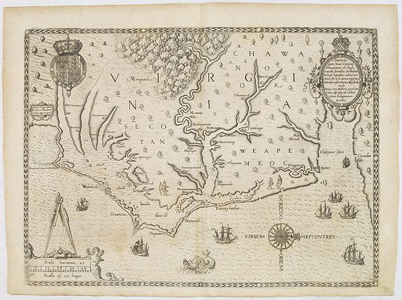
Americae pars, Nunc Virginia dicta, primum ab Anglis. . . |
||||||||||||||||||||
|
||||||||||||||||||||
|
|
||||||||||||||||||||
|
Selling price: $12010
Sold Join our News Letter to get informed when a similar item comes available. Do you have an example you would like to sell? |
Views: 225
|
|||||||||||||||||||
Description
John White's map, elegantly designed and superbly engraved, revolutionized geographic knowledge of the region. Although White left the Chesapeake poorly explored, much of his coastal data became the principal source for subsequent mappings for many years. John White was governor of the ill-fated Roanoke colony in North Carolina that was the first English attempt to settle North America.
The earliest collectible map of Virginia and North Carolina and also the earliest to show and name the Chesapeake Bay.
Its numerous pictorial elements include English ships outside the Outer Banks and at the entrance of Chesapeake Bay, Indian canoes around the Albemarle and Pamlico Sounds, Indian figures, the royal arms of England, etc. With the motto of the British Order of the Garter ("Honi soit qui mal y pense").
Quinn describes the map as the most careful detailed piece of cartography for any part of North America to be made in the sixteenth century.
De Bry's Virginia come in three variations. This state (3) shows the town of Ehesepioc with the E erased, being replaced with a C, changing it to Chesepioc. A slight remnant of the E still remains, and the according to Philip Burden the extremely rare third state.
John White accompanied Sir Walter Raleigh on his 1585 expedition into Virginia and modern-day North Carolina. He assisted in selecting the location of the Roanoke Colony, later served as governor, and found the colony deserted in 1590 upon returning from England. He was the grandfather of Virginia Dare, the first child born to English colonists in America.
Reference: Quinn, Roanoke Voyages, 847-8: Burden, North America, 76 -State 3.
FAQ - Guarantee - Shipping
In our BUY-or-BID sale, you never pay more than the Buy price.
To buy or bid in this Buy-or-Bid sale you must register with us. It is free, and we automatically update you about future auctions.During the Buy-or-Bid sale, you can buy or bid on 600- 900 antique, rare maps, town views, old master prints, decorative prints, atlases, posters and Medieval manuscripts.
- We show the "Bid & Ask spread" (to define the gap between the minimum accepted bid and Buy price.)
- Items that have received bids within the BidAsk spread are sold at the highest bid at closing.
- Once the Buy price is paid, the sale for this item has closed.
Do you have a similar item you want to sell ?
Interested in selling your antique maps, original prints, vintage posters, or historic Ephemera?Let us help you!
Start your consignment today. We provide estimates free of charge from photographs sent via the Internet. Fill out our online estimation form, and we will contact you with an estimate.
Learn more about consigning at RarePaperSales.com
Guarantee
 We warranty the authenticity of each lot offered in our sale. There is no time limitation to this guarantee.
- Defects in lots have been carefully noted.
- If there are no remarks regarding splits, tears, discoloration, etc., there are no issues to be found for the item!
- All items are carefully and personally examined before being packed "in-house" and shipped by UPS, USPS, DHL or registered mail.
- We do not sell reproductions.
- A certificate of authenticity is provided for each acquired item and can be downloaded from your invoice page.
- Certificates can be found in the Invoice and Certificates center.
Shipping
Maps are shipped in solid tubes or flat between solid cardboard. Fully insured, signature required, and with online tracking. Shortly after shipment, you will get the tracking number by email.The standard is that we ship items by UPS or DHL for European destinations, and a flat shipping fee is added to each shipment. It is a one-time fee even if you buy multiple items. This fee covers shipping and insurance (up to the invoice amount) to:
- North America, Canada, Europe $ 30
- Asia $ 40
- For South America, Mauritius, Africa and Australia a shipping fee of $ 50 will be charged.
We charge only a one-time shipping fee if you have won 2 or more items.

Hold Shipment Service
Rare Paper Sales allows you to put your shipping on hold at no additional charge. This can be incredibly convenient for people who want to buy several items at different auctions and ship them together. The service is free, and you pay only one shipment fee.
Contact us if you want to use the Hold Service.
High-Resolution Digital Image Download |
|
|
RarePaperSales maintains an archive of most of our high-resolution rare maps, prints, posters and medieval manuscript scans. We make them freely available for download and study. Read more about free image download |
Click this image for a free HR-image download. |