Lot #: 84683
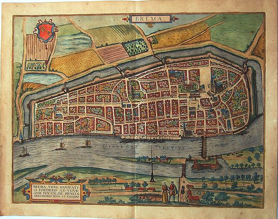
BREMA [BREMEN.] |
||||||||||||||||||||
|
||||||||||||||||||||
|
|
||||||||||||||||||||
|
This item has been sold.
Selling price: $350 Sold in 2020 Join News Letter to get informed when a similar item comes available. |
Views: 232
|
|||||||||||||||||||
Description
A fine antique map - bird's-eye view of Bremen by Braun and Hogenberg, from the rare: Urbium Praecipuarum Mundi Theatrum Quintum Auctore Georgio Braunio Agrippinate. Part 5. Köln, 1596 by Braun and Hogenberg.
TRANSLATION OF CARTOUCHE TEXT: Bremen, well-fortified and through trade a rich and flourishing Hanseatic city on the Weser.
COMMENTARY BY BRAUN (on verso): "The citizens of the city are either merchants or artisans, and there is an inordinate number of skilled shipwrights. By nature they are quarrelsome, clever and tend towards rebellion, as testified by past and recent history. For this reason the burgomaster of Bremen, Ditmar Kenkel, although a learned man, was obliged to leave the city with other councillors, as he has declared in a book published in Ursel in 1565. [...]
There is a large wide market square where all sorts of vital necessities are sold every week. In the middle of the square stands a statue of the Emperor and King, holding only the sword of justice in his hand. One side of the market is dominated by the cathedral, the other by the town hall."
The city is seen from the southwest across the Weser. This is a bird's-eye view of the city with its strictly geometric plan, whereby the perspective is greatly distorted by the figures in the foreground and the extremely steep angle of the far bank of the Weser. Emphasis is placed upon the city's situation on the navigable Weser, which flows out to the North Sea at modern-day Bremerhaven some 60 km to the north.
The large marketplace (Forum) in front of the town hall (Curia) can be identified by the statue of Roland, the city's symbol of liberty erected in 1404, and by the cathedral with its two towers of different heights. Although the people of Bremen possessed ocean-going ships in the form of their Hanse cogs from the 12th century onwards, inland navigation also remained important.
Thus Bremen became an important point on intersection between domestic and foreign trade, which led in the 16th century to economic prosperity. (Taschen)
Reference: References: Van der Krogt 4, 618, State 2; Taschen, Braun and Hogenberg, p.392.
FAQ - Guarantee - Shipping
Rarepapersales has been discontinued.
You can now bid on old maps on the Liveauctioneers platform.These auctions are hosted by NewWorldCartographic from Chicago.
Paulus Swaen keeps selling their maps on its own platform www.swaen.com