Lot #: 85472
BRITISH NORTH AMERICA, - Carte Qui Contient Une Description Des Iles & Terres Que Les Anglois . . . |
||||||||||||||||||||
|
||||||||||||||||||||
|
|
||||||||||||||||||||
|
|
Views: 299
|
|||||||||||||||||||
Description
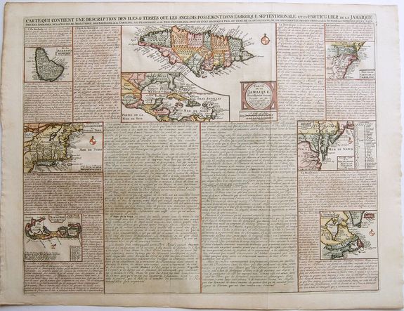
An attractive and interesting sheet from Chatelain's 'Atlas Historique' depicting and describing British territorial claims in North America and the West Indies. New England, Virginia, the Carolinas, Canada, Bermuda, and Barbados are all shown.
A map of Jamaica takes pride of place front-and-centre, with an inset map of the whole Caribbean. Each are accompanied by informative descriptions of the population, history, and produce of the territories depicted.
Includes 8 maps, each of which would be highly coveted as a separate map. The maps include (1) a map of the Carolinas, (2) a map of the Chesapeake, (3) Canada and New England, (4) New England and New York, (5) Bermuda, (6) Barbados (7) Jamaica and (8) Florida. Also includes substantial explanatory text for the Gulf Coast, Mexico, Central America and the Caribbean.
The descriptions should not be taken as authoritative. For instance, the position of New England is described as being “situee au nord de Mariland & au sud de la virginie” (situated to the north of Maryland and south of Virginia.)
Henri Abraham Chatelain (1684-1743) was a Huguenot pastor of Parisian origins. Chatelain proved a successful businessman, creating lucrative networks in London, The Hague, and then Amsterdam.
He is most well known for the 'Atlas Historique', published in seven volumes between 1705 and 1720. This encyclopaedic work was devoted to the history and genealogy of the continents, discussing such topics as geography, cosmography, topography, heraldry, and ethnography.
Published thanks to a partnership between Henri, his father, Zacharie, and his younger brother, also Zacharie, the text was contributed to by Nicolas Gueudeville, a French geographer. The maps were by Henri, largely after the work of Guillaume Delisle, and they offered the general reader a window into the emerging world of the eighteenth century.
FAQ - Guarantee - Shipping
Rarepapersales has been discontinued.
You can now bid on old maps on the Liveauctioneers platform.These auctions are hosted by NewWorldCartographic from Chicago.
Paulus Swaen keeps selling their maps on its own platform www.swaen.com