Lot #: 39375
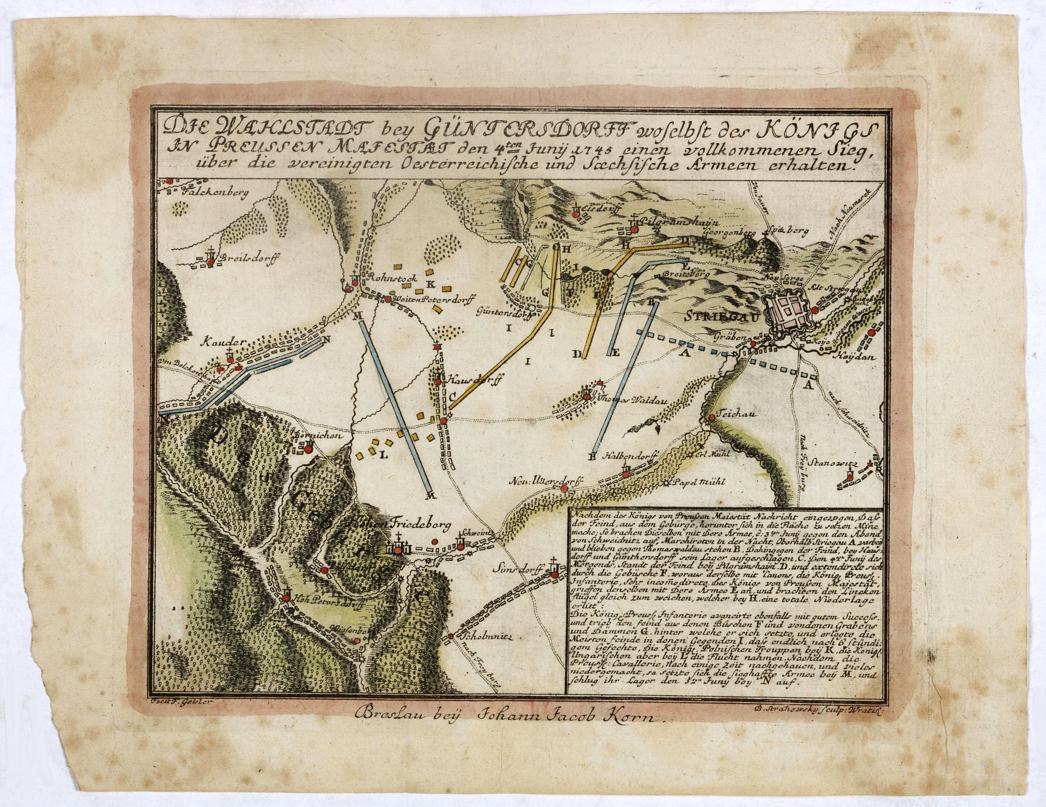
Die Wahlstadt beij Güntersdorff woselbst des Königs in Preussen Mafestaet den 4ten Junij 1745. . . [Battle of Hohenfriedberg] |
||||||||||||||||||||
|
||||||||||||||||||||
|
|
||||||||||||||||||||
|
This item has been sold.
Selling price: $950 Sold in 2018 Join News Letter to get informed when a similar item comes available. |
Views: 429
|
|||||||||||||||||||
Description
A scarce separately issued plan of the Battle of Hohenfriedberg, one of Frederick the Great’s most estimable victories, engraved by the Polish master Bartlomiej Strachowski, and published in Breslau (Wroclaw).
This scarce separately issued map was printed in Breslau, Silesia (today’s Wroclaw, Poland), and is one of the very few cartographic works made by the Polish master engraver Bartlomiej Strachowski (1693 - 1759). It depicts the Battle of Hohenfriedenberg (June 4, 1745), fought between the towns of Streigau (Strzegom) and Dobromierz (Hohenfriedenberg), in Silesia, during the Second Silesian War (1744-5).
The epic battle was enjoined between the massive armies of Frederick the Great of Prussia versus a combined Austro-Saxon force. Frederick scored a crushing victory, so preserving Prussian rule over Silesia and solidifying his reputation as “The Great.”
The Battle of Hohenfriedberg and the Contest for Silesia.
The Prussian King Frederick II ‘The Great’ (1712-86, reigned 1740-86) was one of the greatest field commanders who ever lived and the arch-nemesis of the Austrian Habsburg Empire, ruled by Maria Theresa. During the First Silesian War (1740–2), a part of the larger War of the Austrian Succession (1740-8), Frederick conquered the wealthy province of Silesia from the Austrians. Vienna never accepted this, and during the Second Silesian War (1744–45), they, with the assistance of their Saxon allies, assembled a massive army of 65,000 men under Prince Charles Alexander of Lorraine (1712-80) to reconquer Silesia.
Frederick knew that the Austrians were coming, and he kept his cool as he prepared for the inevitable. While he was outnumbered, having only 58,500 troops, he remained confident of his force’s superior abilities, predicting that the Austro-Saxons would make “some stupid mistakes.”
The Austro-Saxon army invaded Silesia and met Frederick’s Prussians just outside of the village of Streigau (today Strzegom, Poland) on June 4, 1745. As shown on the map, the Prussian lines, in blue, guarded the town, while the Austro-Saxons, held lines to the west, colored in yellow, towards the town of Hohenfriedenberg (today Dobromierz). As the armies enjoined battle, the Austro-Saxon line initially held firm, seemingly impervious to the Prussian artillery. Heavy smoke from the cannons and muskets clouded the field, giving the Austro-Saxons useful cover but also prompting them to make a “stupid mistake.” Suddenly, a gust of wind blew the smoke away, revealing a gap in the Austro-Saxon lines. Frederick’s Bayreuth Dragoons, 1,500 strong, charged through this gap, and within minutes, the Austro-Saxon force fell into disarray. The map shows this movement, where the blue Prussian lines have wheeled around the Austro-Saxon’s right flank. Prince Charles Alexander’s force was routed with heavy casualties and forced to retire from the vicinity. The defeat effectively ended the Austrian’s chances of regaining Silesia, and, on the other side, it cemented Frederick’s reputation as a peerless field commander. Following the battle, Frederick personally composed the Hohenfriedenberger March in celebration of the triumph.
Bartlomiej Strachowski: Master Polish Engraver.
While the author of the map is noted as the mysterious ‘F. Gelster’, the map was engraved and quite likely designed by Bartlomiej Strachowski (1693 - 1759), an important Polish engraver and illustrator based in Breslau, Silesia (today Wroclaw, Poland). He is thought to have hailed originally from Pomerania and arrived in Wroclaw in 1711, where he apprenticed as an engraver before setting up his own establishment. His great talent ensured that he was soon renown throughout Silesia and Poland, undertaking commissions for the royal government and various institutions of the Roman Catholic Church, maintaining especially close ties to the various Jesuit publishing houses. Strachowki is particularly well known for his exquisite engravings of religious themes in both the late Baroque and Rococo styles, which adorned missals and bibles. He also made engravings of the interior of churches and devotional works of art, some of which are prized as being of great historical importance, for they showcase artifacts that were destroyed in World War II and are only known today from Strachowski’s renderings.
Upon Bartlomiej’s death in 1759 his business was continued with great success by his three sons until 1788. It is estimated that the Strachowski house produced at least 2,000 engravings for as many as 800 publications, although most of these works are today quite rare.
Bartlomiej Strachowski produced very few maps. Other that the present map, we know of only a single other map crated by Strachowski, being a magnificent map sheet of the Balearic Islands, Mappa Wyspy Minorki z planta Portu y miasta Mahon z namesake fortyfikacyami port zaslaniaiacemi mappy de Bellin, which appeared within very rare work, Krótkie ale fundamentalne opisanie Balearyjskich i Pythyuzyjskich Wysp Majorca, Minorca, Ivica i Formentera z dowodnieyszych i nowszych relacyi zebrane i do drukowania z niemieckiego (Warsaw: Jesuit Press, 1756).
The present map is scarce – we can trace only 3 institutional examples, being at the Landesarchiv Baden-Württemberg (Stuttgart), Národní knihovna CR (Prague), and the Österreichischen Nationalbibliothek (Vienna).
Reference: Österreichischen Bibliothekenverbundes: AC04457228.
FAQ - Guarantee - Shipping
Rarepapersales has been discontinued.
You can now bid on old maps on the Liveauctioneers platform.These auctions are hosted by NewWorldCartographic from Chicago.
Paulus Swaen keeps selling their maps on its own platform www.swaen.com