Lot #: 33640
Londinium Feracissmi Angliae Regni Metropolis. |
||||||||||||||||||||
|
||||||||||||||||||||
|
|
||||||||||||||||||||
|
Selling price: $5400
Sold in 2013 Join our News Letter to get informed when a similar item comes available. Do you have an example you would like to sell? |
Views: 196
|
|||||||||||||||||||
Description
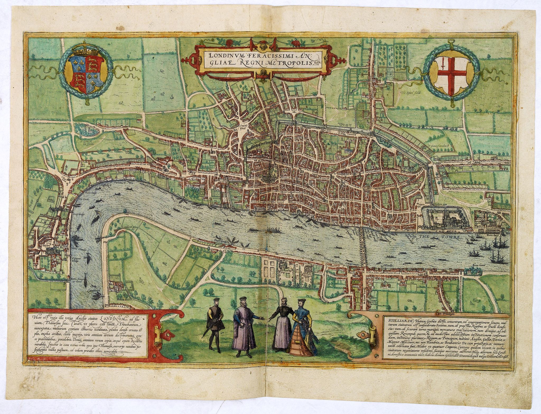
Very desirable and early plan of London - in a second state - shown from the Tower to Westminster, with the City already built-up and a ribbon development westwards along the Strand. On the south bank bull- and bear-baiting rings are prominent.
From the Civitates Orbis.
Although published in 1572, the plan is clearly based upon information gathered some years earlier. St Paul's is shown with its spire, which was destroyed in 1561, the cross in St Botolph's Churchyard is shown, although it was destroyed in 1559, and York Place, so named in 1557 is given its old name 'Suffolke Place'. Upon the Thames, the royal barge can be seen, together with numerous ferrymen and sailing vessels.
On the south bank of the river is the new district of Southwark, with its theatres, and bull and bear baiting pits. To the left is Westminster - connected to the City by a single road - with Westminster Abbey clearly visible. To the north of Westminster, cows are depicted grazing in open fields.
The second state with "West Muster" and no longer like in the first edition "West Mester".
The arms of Elizabeth are displayed in the top left hand corner and the arms of the city on the right.
From volume one of the greatest publication in this genre!. The Civitates was compiled and written by George Braun, Canon of Cologne Cathedral. Braun gathered together vast amounts of information and draft plans to produce over 500 city views/maps published in six parts between 1572 and 1617. Most of these engravings were made by Simon Novellanus and Frans Hogenberg, many after drawings by Joris Hoefnagel.
Read more about the Civitates Orbis.
Reference: Howgego 2, Koeman (1967-70) B & H 1-5, NMM III, i, 459 (1573-1618 ed.), Introduction', in: G. Braun and F. Hogenberg, Civitates orbis terrarum (Amsterdam: 1965). (2)
FAQ - Guarantee - Shipping
In our BUY-or-BID sale, you never pay more than the Buy price.
To buy or bid in this Buy-or-Bid sale you must register with us. It is free, and we automatically update you about future auctions.During the Buy-or-Bid sale, you can buy or bid on 600- 900 antique, rare maps, town views, old master prints, decorative prints, atlases, posters and Medieval manuscripts.
- We show the "Bid & Ask spread" (to define the gap between the minimum accepted bid and Buy price.)
- Items that have received bids within the BidAsk spread are sold at the highest bid at closing.
- Once the Buy price is paid, the sale for this item has closed.
Do you have a similar item you want to sell ?
Interested in selling your antique maps, original prints, vintage posters, or historic Ephemera?Let us help you!
Start your consignment today. We provide estimates free of charge from photographs sent via the Internet. Fill out our online estimation form, and we will contact you with an estimate.
Learn more about consigning at RarePaperSales.com
Guarantee
 We warranty the authenticity of each lot offered in our sale. There is no time limitation to this guarantee.
- Defects in lots have been carefully noted.
- If there are no remarks regarding splits, tears, discoloration, etc., there are no issues to be found for the item!
- All items are carefully and personally examined before being packed "in-house" and shipped by UPS, USPS, DHL or registered mail.
- We do not sell reproductions.
- A certificate of authenticity is provided for each acquired item and can be downloaded from your invoice page.
- Certificates can be found in the Invoice and Certificates center.
Shipping
Maps are shipped in solid tubes or flat between solid cardboard. Fully insured, signature required, and with online tracking. Shortly after shipment, you will get the tracking number by email.The standard is that we ship items by UPS or DHL for European destinations, and a flat shipping fee is added to each shipment. It is a one-time fee even if you buy multiple items. This fee covers shipping and insurance (up to the invoice amount) to:
- North America, Canada, Europe $ 30
- Asia $ 40
- For South America, Mauritius, Africa and Australia a shipping fee of $ 50 will be charged.
We charge only a one-time shipping fee if you have won 2 or more items.

Hold Shipment Service
Rare Paper Sales allows you to put your shipping on hold at no additional charge. This can be incredibly convenient for people who want to buy several items at different auctions and ship them together. The service is free, and you pay only one shipment fee.
Contact us if you want to use the Hold Service.
High-Resolution Digital Image Download |
|
|
RarePaperSales maintains an archive of most of our high-resolution rare maps, prints, posters and medieval manuscript scans. We make them freely available for download and study. Read more about free image download |
Click this image for a free HR-image download. |