Lot #: 85051
Mappe-Monde Geo-Hydrographique, ou Description Generale du Globe Terrestre et Aquatique en Deux Plans-Hemispheres. . .[FIRST PLATE IN FIRST STATE] |
||||||||||||||||||||
|
||||||||||||||||||||
|
|
||||||||||||||||||||
|
|
Views: 371
|
|||||||||||||||||||
Description
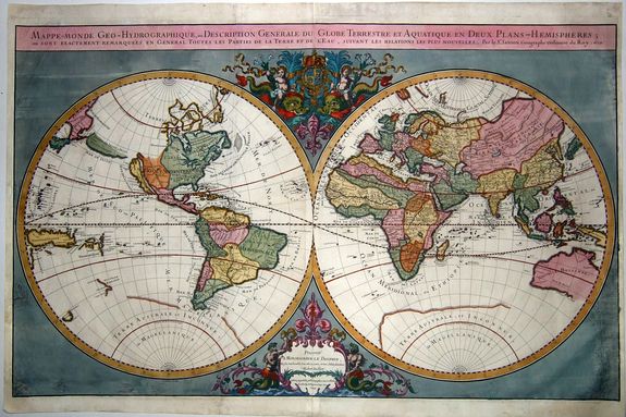
VERY RARE FIRST PLATE IN FIRST STATE. An extra-large copper-engraved twin-hemisphere world map on two sheets. With a coat-of-arms of and dedication to the Dauphin of France.
An elegant double hemisphere world map published by Alexis-Hubert Jaillot, featuring the latest discoveries and decorative embellishments. Particularly interesting geographic features include California as an island, a sparse and unknown southern continent, and the recent coastal encounters in New Zealand, Australia, and Van Diemen’s Land (Tasmania).
The dual hemispheres are contained within a relatively simple frame which centers the map’s geography as the most important component. The title is enclosed in a simple banner at top of the map frame and notes the original creator of this map as renowned French cartographer Nicolas Sanson. Jaillot worked with Nicolas Sanson’s sons and reworked and re-released many of his maps.
The eastern hemisphere includes a remarkably complete western portion of Australia, based on Dutch encounters with the continent dating from the early seventeenth century. To the south is an immense coastline left unfinished as it meanders to the east. This is the great Southern Continent, assumed to exist to counterbalance the northern continental landmasses but in 1674 still a mere idea.
North America is divided to show the various imperial powers who were then vying for control of the continent. Spain controlled what is labeled here as California (an island), New Mexico, New Spain, and Florida. To the north is the vast forested expanse of New France, while the tiny English colonies cling to the Eastern seaboard.
The northwest coast is left blank, said to house the outlet of a Northwest Passage to China. Searches for this passage have helped to fill in the northeast of the continent, although Greenland is connected to Canada and the precise extent of Baffin’s Bay and Hudson’s Bay remains unknown. This map also provides an early delineation of the Great Lakes.
Evidence of Maarten Gerritz de Vries 1643 expedition in the southern Kuril Islands area is reflected on this map: the de Vries Strait, Cape Patience, Staten Land (Terre des Estats), and Company Land (Terre de la Compagnie) are all marked. Terre de Iesso, likely a misconception of the Japanese island of Hokkaido, was reported by de Vries as smaller islands.
Mapmakers over time re-envisioned Iesso and Company’s Land as a land bridge connected to America. The cartography of this map leaves these options open: Terre de Iesso, drawn only partially and separated from California, seems to suggest a connection to North America.
At the juncture of the two hemispheres are the decorative elements of the map. At the bottom, two large mermen keep a flower-framed cartouche from falling into the sea. The fleur-de-lis, an important symbol in French culture, adorns the top of the frame. Above the hemispheres, cherubs ride dolphins and hold the coat of arms of the Dauphin. "The two hemispheres are drawn on an enlarged scale, engraved with distinction, and usually printed on heavy quality paper. The limited decoration enhances the overall effect: at the top cherubs with flowing banners are seated astride dolphins and support the arms of France. At the bottom, a bold cartouche is flanked by two twin-tailed mermen"
This map is an enlarged version of Nicolas Sanson’s original world map. Jaillot worked with Sanson’s sons Guillaume and Adrien to publish this work. From 1681, the map was incorporated into Jaillot’s Atlas Nouveau.
Plate I includes the signature of the engraver Cordier and comes in four states dated 1674, 1679, 1681, and 1684. Plates II-IV are not signed by Cordier. Plate II, dated 1674 uses the Latin “v” for “u”, and is dated 1674 although Shirley notes it may predate Plate I. Plate III is dated 1687. Plate IV was newly engraved for the Atlas Nouveau of 1691 and comes in three states. The second state of Plate IV is dated 1696, and its third state is undated.
Alexis-Hubert Jaillot (ca. 1632-1712) was one of the most important French cartographers of the seventeenth century.
Jaillot traveled to Paris with his brother, Simon, in 1657, hoping to take advantage of Louis XIV's call to the artists and scientists of France to settle and work in Paris. Originally a sculptor, he married the daughter of Nicholas Berey, Jeanne Berey, in 1664, and went into partnership with Nicholas Sanson's sons. Beginning in 1669, he re-engraved and often enlarged many of Sanson's maps, filling in the gap left by the destruction of the Blaeu's printing establishment in 1672.
Reference: Shirley (World), 462-IV,1, Pastoureau, Jaillot I-D,1. John Leighly, California as an Island: An Illustrated Essay (San Francisco: Book Club of California, 1972); Glen McLaughlin with Nancy H. Mayo, “The Mapping of California as an Island: An Illustrated C
FAQ - Guarantee - Shipping
Rarepapersales has been discontinued.
You can now bid on old maps on the Liveauctioneers platform.These auctions are hosted by NewWorldCartographic from Chicago.
Paulus Swaen keeps selling their maps on its own platform www.swaen.com