Lot #: 15783
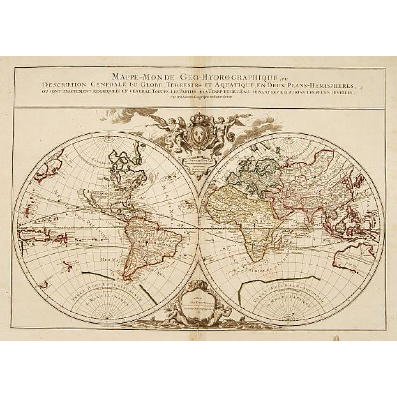
Mappe-Monde Geo-Hydrographique, ou Description Generale.. |
||||||||||||||||||||
|
||||||||||||||||||||
|
|
||||||||||||||||||||
|
Selling price: $1500
Sold Join our News Letter to get informed when a similar item comes available. Do you have an example you would like to sell? |
Views: 380
|
|||||||||||||||||||
Description
"MAP OF THE WORLD DEDICATED TO LOUIS XIV.
Large map of the world in two hemispheres, in a stereographic projection (each hemisphere 31.5 cm in diameter). California seems to be connected to the mainland, rather than appearing as an island, but the placement of the lettering slightly obscures the connection. The map in its first state, dated ,169, and dedicated to King Louis XIV, appears in (Antoine-)Hubert Jaillot's 1695 Atlas François. It was engraved by (Louis) Cordier. Shirley mentions states of the plate dated 1700 and 1706, but gives no locations; and Pastoreau still records the ,169, state in a copy of the 1700 edition of Jaillot's atlas. With title in a panel across the head, imprint in a decorative cartouche with mermaids and dolphins at the foot, and dedication to the (by this time deceased) King Louis XIV in a cartouche above, under the royal arms supported by 2 angels, 1 with a trumpet.
Jaillot and his heirs continued to publish his atlas with the 1700 date on the title-page for many years, and Pastoreau records copies with the ,Mappe-Monde, printed from the plate in the 1706 and the present 1719 states. The original dedication to Louis XIV had conveniently said simply ,Dedié au Roy,, so after he died in 1715, leaving the government in the hands of the regents until Louis XV came of age in 1723, the revisors of the map let the dedication to the unnamed king stand.
The plate was apparently not revised again after 1719, but Jaillot's heirs continued to use it so that the map appears in their atlases for twenty years into the reign of Louis XV.
The literature records no copies of Jaillot's atlas later than 1738, but that date is based on the engraved date in one of the maps, so some copies recorded under that date may be somewhat later. The present copy of the ,Mappe-Monde, is watermarked ,J (or I) [pillar topped by ,T,] DUPVY MOYEN|AUVERGNE 1742, = chaplet (cf. Heawood 238), and was formally bound with other maps from Jaillot's atlas with similar 1742 Dupuy watermarks, as well as other maps (with different watermarks) probably issued by Gilles Robert in the years 1742-1745. From 1731 Jaillot's firm was in the hands of his grandson Bernard-Antoine (d. 1749). Still a good copy of an attractively decorated map of the world.
Reference: Cat. Nat. Mar. Mus. III, 240, map 70; Pastoureau, Jaillot II C-D, G & I map 1 (cf. map 1 in II A, E & F); Phillips & LeGear 534, map 1; this state not mentioned in Shirley (cf. 569); Lexikon Gesch. Kartographie, pp. 353-354 & 699-701."
Reference: "
FAQ - Guarantee - Shipping
In our BUY-or-BID sale, you never pay more than the Buy price.
To buy or bid in this Buy-or-Bid sale you must register with us. It is free, and we automatically update you about future auctions.During the Buy-or-Bid sale, you can buy or bid on 600- 900 antique, rare maps, town views, old master prints, decorative prints, atlases, posters and Medieval manuscripts.
- We show the "Bid & Ask spread" (to define the gap between the minimum accepted bid and Buy price.)
- Items that have received bids within the BidAsk spread are sold at the highest bid at closing.
- Once the Buy price is paid, the sale for this item has closed.
Do you have a similar item you want to sell ?
Interested in selling your antique maps, original prints, vintage posters, or historic Ephemera?Let us help you!
Start your consignment today. We provide estimates free of charge from photographs sent via the Internet. Fill out our online estimation form, and we will contact you with an estimate.
Learn more about consigning at RarePaperSales.com
Guarantee
 We warranty the authenticity of each lot offered in our sale. There is no time limitation to this guarantee.
- Defects in lots have been carefully noted.
- If there are no remarks regarding splits, tears, discoloration, etc., there are no issues to be found for the item!
- All items are carefully and personally examined before being packed "in-house" and shipped by UPS, USPS, DHL or registered mail.
- We do not sell reproductions.
- A certificate of authenticity is provided for each acquired item and can be downloaded from your invoice page.
- Certificates can be found in the Invoice and Certificates center.
Shipping
Maps are shipped in solid tubes or flat between solid cardboard. Fully insured, signature required, and with online tracking. Shortly after shipment, you will get the tracking number by email.The standard is that we ship items by UPS or DHL for European destinations, and a flat shipping fee is added to each shipment. It is a one-time fee even if you buy multiple items. This fee covers shipping and insurance (up to the invoice amount) to:
- North America, Canada, Europe $ 30
- Asia $ 40
- For South America, Mauritius, Africa and Australia a shipping fee of $ 50 will be charged.
We charge only a one-time shipping fee if you have won 2 or more items.

Hold Shipment Service
Rare Paper Sales allows you to put your shipping on hold at no additional charge. This can be incredibly convenient for people who want to buy several items at different auctions and ship them together. The service is free, and you pay only one shipment fee.
Contact us if you want to use the Hold Service.
High-Resolution Digital Image Download |
|
|
RarePaperSales maintains an archive of most of our high-resolution rare maps, prints, posters and medieval manuscript scans. We make them freely available for download and study. Read more about free image download |

