Lot #: 84775
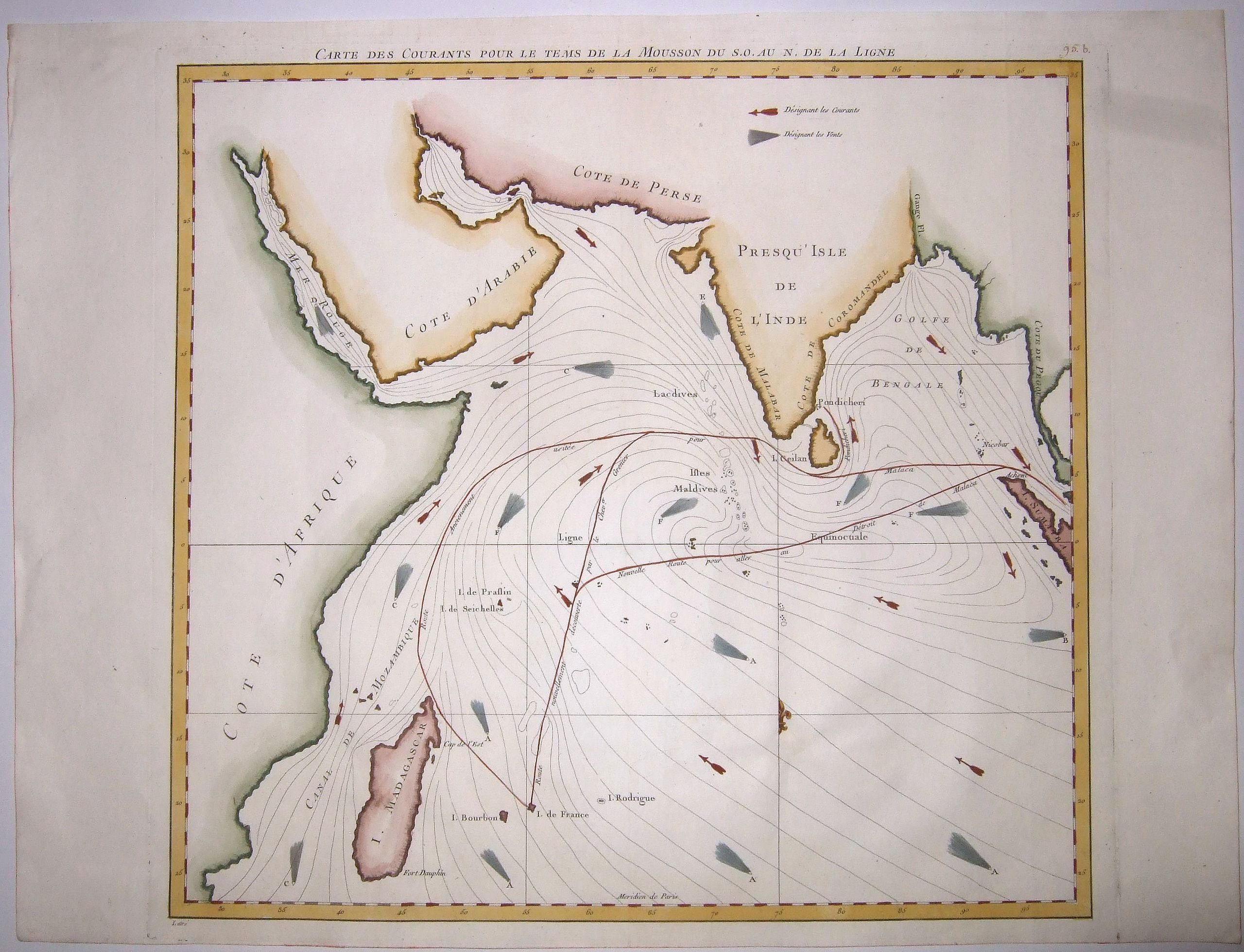
[PASSAGE TO INDIA], CARTE DES COURANTS POUR LE TEMS DE LA MOUSSON DU S.O. AU N. DE LA LIGNE. |
||||||||||||||||||||
|
||||||||||||||||||||
|
|
||||||||||||||||||||
|
|
Views: 264
|
|||||||||||||||||||
Description
Highly Important and Rare – a great monument of
Enlightenment Era thematic cartography – Vicomte Grenier’s of sea chart
showcasing his new, faster sailing routes across the Indian Ocean,
discoveries which revolutionized European-Asian transportation and
geopolitics.
A fine antique naval chart, probably representing the Indian Ocean during the period of the Winter, or South-West Monsoon, during which, from roughly April to August, strong winds sweep towards the Indian Subcontinent from down of the Equator.
Jacques-Raymond de Grenier (1736‒1803) was a naval officer and hydrographer, best known for his maps of the Indian Ocean. De Grenier spent the years 1768‒1769 and 1772‒1776 exploring and mapping the many islands in the Indian Ocean, particularly those where the French had colonial possessions and interests. He recounted his discoveries in the work entitled 'Mémoires de la Campagne de Découverte dans les Mers des Indes', published in 1770. During his research on the prevailing currents and winds during the southwest and northeast monsoons in the The Indian Ocean, de Grenier discovered more direct, and therefore faster, routes to and from the French colonial possessions in India, notably the Coromandel coast and a passage to the Strait of Malacca, thus reducing the distance of these voyages to 'approximately 3,200 kilometres.
This map shows the route from Isle de France (Mauritius) to the East Indies, once taken by French navigators, northwesterly, past the tip of Madagascar and along the eastern coast of the Africa before moving east off Ceylon (Sri Lanka) to Sumatra.
It represents the currents and winds mapped by de Grenier, and the new course he discovered, involving sailing more directly north before heading east to reach the equator through the Strait of Malacca. Originally engraved by Jean Lattré in 1776, this map was included in Neptune oriental by Jean-Baptiste d'Après de Mannevillette, and in later editions by Bellin.
From: 'Hydrographie Françoise', vol. 2, 95 b [numbered by hand.]
Reference: https://gallica.bnf.fr/ark:/12148/btv1b53105337q/f2.item
FAQ - Guarantee - Shipping
Rarepapersales has been discontinued.
You can now bid on old maps on the Liveauctioneers platform.These auctions are hosted by NewWorldCartographic from Chicago.
Paulus Swaen keeps selling their maps on its own platform www.swaen.com