Lot #: 42275
Pleasure Island : Being A Plan in the Old Manner of the Lake Island in Canada which Mr Winston Churchill is said to covert. |
||||||||||||||||||||
|
||||||||||||||||||||
|
|
||||||||||||||||||||
|
Selling price: $75
Sold in 2019 Join our News Letter to get informed when a similar item comes available. Do you have an example you would like to sell? |
Views: 152
|
|||||||||||||||||||
Description
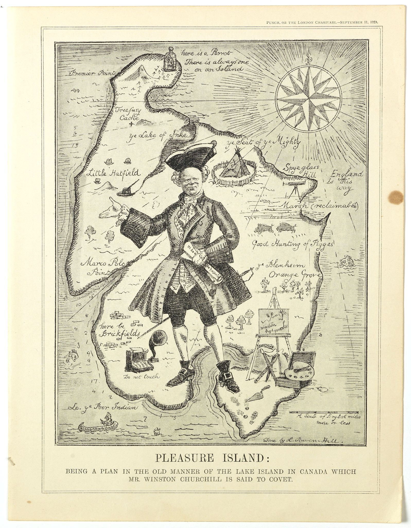
From Punch, September 11th, 1929.
A satirical map attacking Churchill in his "Wilderness Years." In May of 1929, the Conservative government failed to gain reelection, and Churchill lost his position as Chancellor of the Exchequer. Despite his extensive political experience and oratorical skills, the 54-year-old Churchill was unpopular within his own party because he supported free trade and Irish Home Rule. In early August, Churchill left England for a three-month tour of Canada and the United States to build up the North American readership for his books and articles, meet with important political and financial leaders, and search for good investments! Lough, 180-86. Bernard Baruch helped plan the trip, and Churchill's hosts included William Randolph Hearst, Paul Mellon, Samuel McClure, and Charles Schwab of Bethlehem Steel. Ibid.
During the lengthy Canadian leg of his trip, Churchill and his party spent August 19 at Lake of the Woods, Ontario, a lake over 70 miles long with literally thousands of islands, many occupied by luxurious vacation homes. After an exciting motorboat ride and a leisurely lunch at his host's "palatial" home, Churchill announced that he intended to buy one of the islands and make it into "a most beautiful summer residence." "Winston or one of the party with him told the newspapers of this intention to purchase an island, and it was duly reported in the Canadian papers." Tolppanen 77.
The Canadian press reports of the exiled Churchill seeking a remote Canadian retreat apparently proved too much for Punch to resist, and the map appeared three weeks later. It features a giant figure of Churchill astride an island out of traditional pirate-treasure fiction. The geographic points on the island include some references to Churchill's life and career: Blenheim (the ancestral home of the Marlboroughs, where he was born); Hatfield (where he participated in the secret development of the tank in 1916); a typewriter (labeled "do not touch"); an easel and paints; "Treasure Cache;" and at the farthest end of the island, "Premier Point. (Text by P.J. Mode)"
More aboutcartographical curiosities [+]
Reference: Persuasive Maps, PJ Mode Collection, 1229.01.
FAQ - Guarantee - Shipping
In our BUY-or-BID sale, you never pay more than the Buy price.
To buy or bid in this Buy-or-Bid sale you must register with us. It is free, and we automatically update you about future auctions.During the Buy-or-Bid sale, you can buy or bid on 600- 900 antique, rare maps, town views, old master prints, decorative prints, atlases, posters and Medieval manuscripts.
- We show the "Bid & Ask spread" (to define the gap between the minimum accepted bid and Buy price.)
- Items that have received bids within the BidAsk spread are sold at the highest bid at closing.
- Once the Buy price is paid, the sale for this item has closed.
Do you have a similar item you want to sell ?
Interested in selling your antique maps, original prints, vintage posters, or historic Ephemera?Let us help you!
Start your consignment today. We provide estimates free of charge from photographs sent via the Internet. Fill out our online estimation form, and we will contact you with an estimate.
Learn more about consigning at RarePaperSales.com
Guarantee
 We warranty the authenticity of each lot offered in our sale. There is no time limitation to this guarantee.
- Defects in lots have been carefully noted.
- If there are no remarks regarding splits, tears, discoloration, etc., there are no issues to be found for the item!
- All items are carefully and personally examined before being packed "in-house" and shipped by UPS, USPS, DHL or registered mail.
- We do not sell reproductions.
- A certificate of authenticity is provided for each acquired item and can be downloaded from your invoice page.
- Certificates can be found in the Invoice and Certificates center.
Shipping
Maps are shipped in solid tubes or flat between solid cardboard. Fully insured, signature required, and with online tracking. Shortly after shipment, you will get the tracking number by email.The standard is that we ship items by UPS or DHL for European destinations, and a flat shipping fee is added to each shipment. It is a one-time fee even if you buy multiple items. This fee covers shipping and insurance (up to the invoice amount) to:
- North America, Canada, Europe $ 30
- Asia $ 40
- For South America, Mauritius, Africa and Australia a shipping fee of $ 50 will be charged.
We charge only a one-time shipping fee if you have won 2 or more items.

Hold Shipment Service
Rare Paper Sales allows you to put your shipping on hold at no additional charge. This can be incredibly convenient for people who want to buy several items at different auctions and ship them together. The service is free, and you pay only one shipment fee.
Contact us if you want to use the Hold Service.
High-Resolution Digital Image Download |
|
|
RarePaperSales maintains an archive of most of our high-resolution rare maps, prints, posters and medieval manuscript scans. We make them freely available for download and study. Read more about free image download |
Click this image for a free HR-image download. |