Lot #: 85021
Scheduled
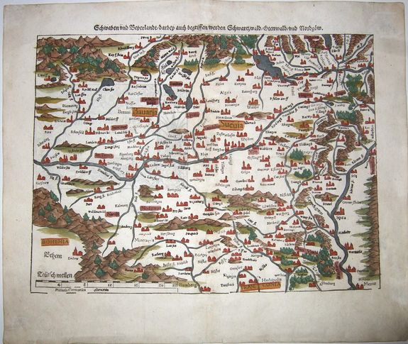
Schwaben und Beyerlandt. . . [Swabia,Bavaria] |
||||||||||||||||||||
|
||||||||||||||||||||
|
|
||||||||||||||||||||
Estimated value: $130 - $190 |
Views: 234
|
|||||||||||||||||||
Description
A double-page woodcut map of Swabia/Schwaben [today partly in Bavaria - partly in Baden-Wuerttemberg], published in Basel, circa 1550. Munster's important early regional map of Germany. Centered on the Danube, with the Rhine at the extreme right side of the map and the Alps at the top.
One of the earliest obtainable modern maps of the region. From a German edition of Munster's 'Geographia', one of the most important 16th Century geographical books.
Swabia is a cultural, historic, and linguistic region in southwestern Germany. The name is ultimately derived from the medieval Duchy of Swabia, one of the German stem duchies, representing the territory of Alemannia, whose inhabitants interchangeably were called Alemanni or Suebi.br />
Sebastian Munster (1489-1552) was one of the three most renowned cartographers of the sixteenth century, along with Mercator and Ortelius. Munster's 'Geographia' and 'Cosmographia Universalis' were two of the most widely read and influential books of the period. His editions of Ptolemy's 'Geographia', published between 1540 and 1552, were illustrated with 48 woodcut maps, the standard 27 Ptolemaic maps, and supplemented by 21 new maps.
These new maps included a separate map of each of the known continents and marked the development of regional cartography in Central Europe. The antique geography was a prelude to Munster's major work, the 'Cosmographia', which was published in nearly 30 editions in six languages between 1544 and 1578 and then was revised and reissued by Sebastian Petri from 1588 to 1628.
The 'Cosmographia' was a geographical as well as a historical and ethnographic description of the world. It contained the maps from the 'Geographia' plus additional regional maps and city views with originally nearly 500 illustrations [later expanded to over 1000] which made it one of the most popular pictorial encyclopedias of the sixteen century.
FAQ - Guarantee - Shipping
Rarepapersales has been discontinued.
You can now bid on old maps on the Liveauctioneers platform.These auctions are hosted by NewWorldCartographic from Chicago.
Paulus Swaen keeps selling their maps on its own platform www.swaen.com