Lot #: 82649
Listing ID: #36503 has been removed from your wishlist.
CARTE REDUITE DES TERRES AUSTRALES. |
||||||||||||||||||||
|
||||||||||||||||||||
|
|
||||||||||||||||||||
|
|
Views: 294
|
|||||||||||||||||||
Description
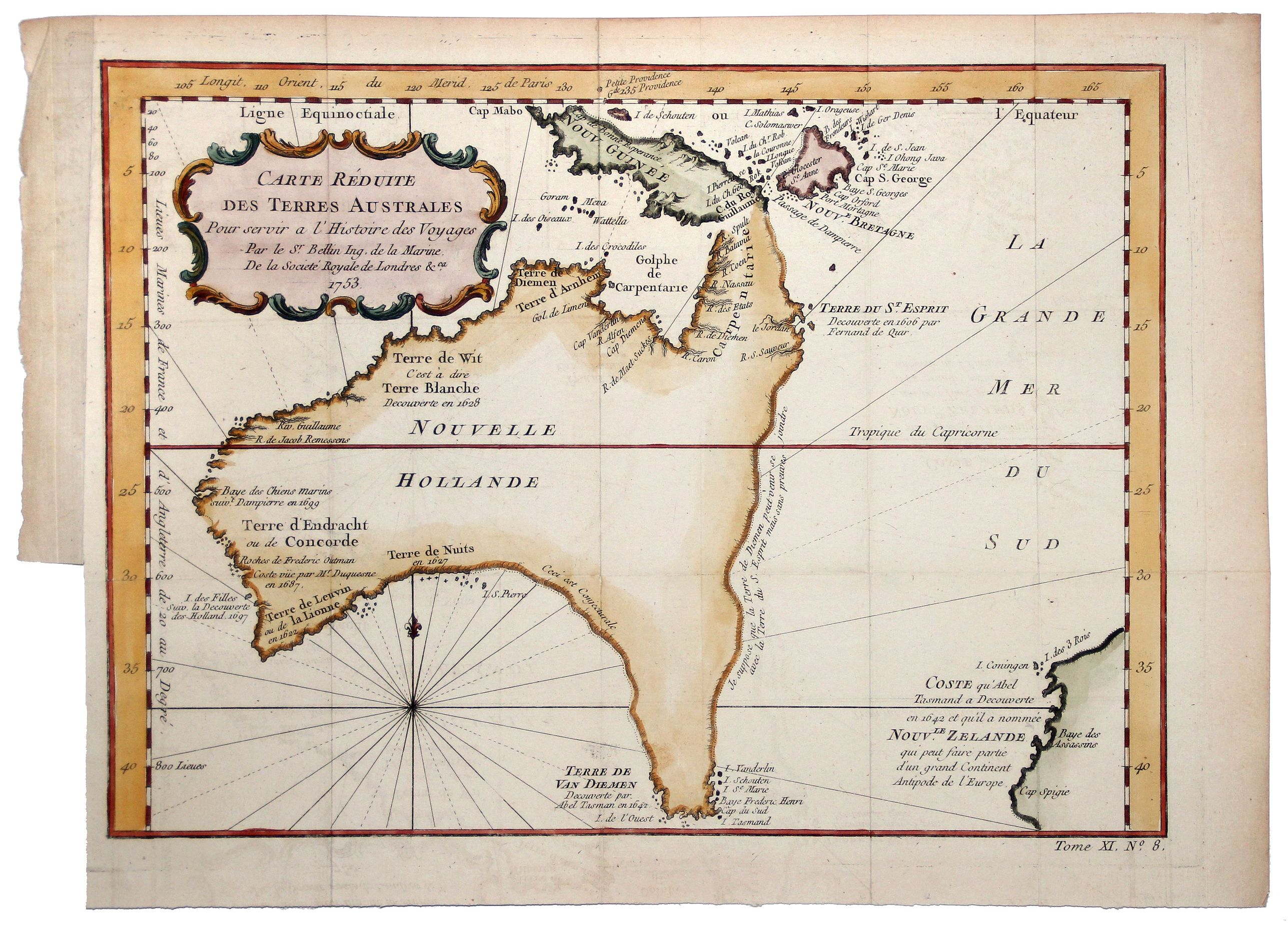
A nice example of Bellin's map of Australia, which featured in the Abbe Prevost’s massive voyage collection, 'Histoire générale des voyages', published from 1746 to 1759. The map shows the latest information available about New Holland, as well as puts forth several theories about the still unknown coasts. It is one of the earliest collectable maps of Australia to not include the Asian continent or the rest of the world.
The map provides a fine early depiction of Australia and shows the coastlines of myth and conjecture which began to form in the seventeenth century and were not fully explored until the early nineteenth century. The northern, western, and southern coastlines of the continent are delineated, but the southeastern and eastern coasts are conjectural.
Van Diemen’s Land is still thought to be connected to the main Australian continent, a hypothesis not disproven until Flinders and Bass’s surveys in the 1790s.
Another conjectural coastline connects Carpentaria, in northeast Australia, to New Guinea. This was a holdover from two centuries of maps that exaggerated the size of New Guinea, but also Bellin’s own combination of other geographic chimeras. In reality, Luís Vaz de Torres, who sailed with Pedro Fernandes de Quiros in 1605, had passed through the straits between New Guinea and Australia.
However, the Spanish had suppressed his report in the hopes of maintaining power via geographic secrecy and the Strait was only rediscovered by Alexander Dalrymple in 1762, when he was researching documents captured from the Spanish in the Philippines during the Seven Years’ War. Later, Cook sailed through the Strait, confirming its existence to the Western world, during his first voyage.
Here, Bellin has connected Van Diemen’s Land with the Australian eastern coast, but he has also attached Terre de St. Esprit. The land, 'Austrialia del Espiritu Santo' was described as paradisiacal by Quiros when he landed there and tried to begin a colony in 1606. His crew forced him to leave, however, and the island was then shifted on maps by subsequent geographers to serve various cartographic hypotheses.
Bellin writes, “Je suppose que la Terre de Diemen peut joindre avec la Terre de St. Esprit mais sans preuve" (I suppose that the land of Diemen could join with the land of the Holy Ghost but this is without proof). Bellin was correct to be skeptical of the connection he drew, for the islands Quiros landed at are now known as Vanuatu and are over one thousand miles from the Australian coast.
FAQ - Guarantee - Shipping
Rarepapersales has been discontinued.
You can now bid on old maps on the Liveauctioneers platform.These auctions are hosted by NewWorldCartographic from Chicago.
Paulus Swaen keeps selling their maps on its own platform www.swaen.com