Lot #: 83632
Listing ID: #38627 has been removed from your wishlist.
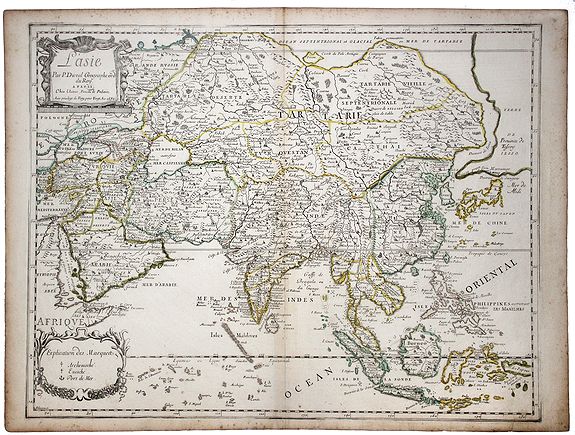
L'Asie par P. Duval Geographe ord du Roy. [Korea as an island] |
||||||||||||||||||||
|
||||||||||||||||||||
|
|
||||||||||||||||||||
|
|
Views: 314
|
|||||||||||||||||||
Description
An antique map titled 'L'Asie', of the Asian continent by Pierre Duval, dated 1664. Most place names represent geographical places that currently exist or once existed.
The rendition of the lower islands of Japan and the peninsula of Korea are improved over earlier studies. Details of the Great Wall of China are also visible. Interesting details are : Korea still shown as an island , and an oversized massive 'Terre de Iesso'/'Province de Tessoy' representing a mix of Hokaido/Sachalin islands and the American west coast / Alaska.
The rendition of the lower islands of Japan and the peninsula of Korea are improved over earlier studies. Details of the Great Wall of China are also visible. Interesting details are : Korea still shown as an island , and an oversized massive 'Terre de Iesso'/'Province de Tessoy' representing a mix of Hokaido/Sachalin islands and the American west coast / Alaska.
FAQ - Guarantee - Shipping
Rarepapersales has been discontinued.
You can now bid on old maps on the Liveauctioneers platform.These auctions are hosted by NewWorldCartographic from Chicago.
Paulus Swaen keeps selling their maps on its own platform www.swaen.com