Lot #: 84008
Listing ID: #39794 has been removed from your wishlist.
![[KALKAR] Calcaria Ducatus Clivensis, Multis Dotibus, Nobile Opp:](/uploads/cache/84008-800x800.jpg)
[KALKAR] Calcaria Ducatus Clivensis, Multis Dotibus, Nobile Opp: |
||||||||||||||||||||
|
||||||||||||||||||||
|
|
||||||||||||||||||||
|
This item has been sold.
Selling price: $120 Sold in 2020 Join News Letter to get informed when a similar item comes available. |
Views: 241
|
|||||||||||||||||||
Description
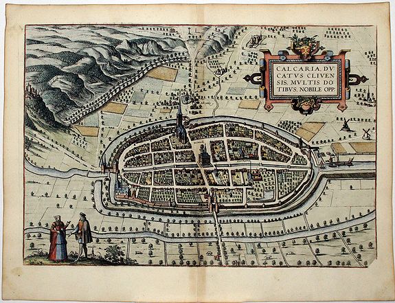
A decorative bird's-eye view plan of Kalkar by Braun and Hogenberg. TRANSLATION OF CARTOUCHE TEXT: Kalkar, a town in the Duchy of Cleves, well known for its many excellent qualities.
COMMENTARY BY BRAUN: "Kalkar was once built on an island in the Rhine by the Count of Cleves, as a defence against Cologne and Guelders, with whom the burghers of Cleves were constantly at war at that time. But now it is a breadbasket for all the surrounding villages and towns, for each week the outlying farmers bring their corn and grain to market here. Kalkar is in a very favourable location, because the grain can be brought here on the Rhine in great ships. Kalkar has a good reputation for this reason, and its privileges also make it one of the most distinguished towns in the Duchy of Cleves."
This bird's-eye view shows the city of Kalkar and its surroundings from the east. The magnificent gate in the middle of the plate is known as the Hanselaer gate. On the left-hand edge of the map can be seen Monterberg castle, one of the most important residences of the Counts of Cleves.
In this plate the town hall stands out clearly, as well as the late Gothic church of St Nicholas, which was consecrated in 1450. On the marketplace stands the so-called court linden tree.
North of the marketplace a caption indicates the Beguinage. Kalkar was granted a municipal charter in 1242 and in the 14th century it concluded an agreement with Goch and Emmerich in respect of cloth production and wool processing. From 1540 to 1572 Kalkar was a Hanseatic city with a population of about 5,000, but this prosperity came to an end in 1598 due to the Dutch Revolt against the Spanish.
More about Braun and Hogenberg, Civitatus [+]
Reference: Taschen, Braun and Hogenberg, p.166.
FAQ - Guarantee - Shipping
Rarepapersales has been discontinued.
You can now bid on old maps on the Liveauctioneers platform.These auctions are hosted by NewWorldCartographic from Chicago.
Paulus Swaen keeps selling their maps on its own platform www.swaen.com