Lot #: 84384
Soest. |
||||||||||||||||||||
|
||||||||||||||||||||
|
|
||||||||||||||||||||
|
This item has been sold.
Selling price: $250 Sold in 2020 Join News Letter to get informed when a similar item comes available. |
Views: 215
|
|||||||||||||||||||
Description
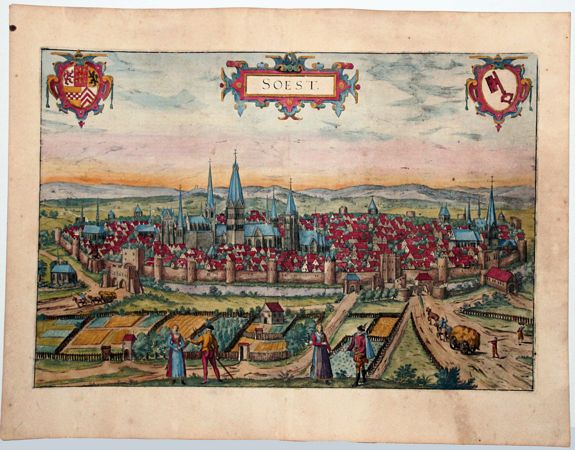
Bird's-eye view of Soest, by Braun and Hogenberg.
COMMENTARY BY BRAUN (on the verso): "After Münster, Soest is the wealthiest and largest city in Westphalia. [...] It is said that it was originally a castle and one of the fortresses that Widukind, who conducted a war against Charlemagne for thirty years, rebuilt several times after it had fallen and been destroyed. [...] It has many nearby villages under its authority, which used to be small bailiwicks but are now called burdens, because they have to bear the burdens and hardships imposed upon them by the burghers."
This plate shows the city from the southeast looking over the Soest Börde, which has fertile loess soil and the additional advantage of a dry climate. The view is dominated by numerous church spires: St Patroclus is considered to be one of the most beautiful Romanesque churches in Westphalia. The other churches and the city walls go back to the period of the city's greatest prosperity, from the 12th to the 14th century. In the 12th century Soest was granted a municipal charter, which became the model for the charters of 65 other cities in northern Germany.
In the Soest Feud of 1444 the city freed itself from the authority of the archbishop of Cologne and declared itself loyal to the Dukes of Cleves in 1448. The present plate shows Soest in cavalier perspective, which gives a better view of the buildings in the city.
More about Braun and Hogenberg, Civitatus [+]
Reference: Van der Krogt 4, 4034; Taschen, Braun and Hogenberg, p. 295.
FAQ - Guarantee - Shipping
Rarepapersales has been discontinued.
You can now bid on old maps on the Liveauctioneers platform.These auctions are hosted by NewWorldCartographic from Chicago.
Paulus Swaen keeps selling their maps on its own platform www.swaen.com