Lot #: 85308
Listing ID: #42375 has been removed from your wishlist.
L'Amerique Meridionale Divisee en ses Principales Parties. . . |
||||||||||||||||||||
|
||||||||||||||||||||
|
|
||||||||||||||||||||
|
This item has been sold.
Selling price: $350 Sold in 2021 Join News Letter to get informed when a similar item comes available. |
Views: 172
|
|||||||||||||||||||
Description
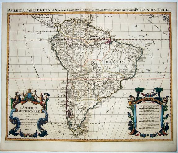
A handsome large-format map of South America by Jaillot, based upon the earlier maps of Nicholas Sanson. From: 'Atlas Royal', Amsterdam, 1694.
Jaillot’s map is well-framed, showing South America with portions of Central America, Africa, and the Cape Verde Islands. The continent’s defining physical features are notable here. The Rio de la Plata curls northwards, studded with islands, and ends in the mythical Lake of Xarayes.
The Amazon winds towards the heart of the landmass, splitting into a feather-like pattern and then weaving its way from smaller rivers in Peru. In the north is a large, rectangular lake, Lake Parime, with the mystical city of Manoa El Dorado on its banks.
In the far south, the Straits of Magellan separate Tierra del Fuego from the mainland. The latter is shown as a single island with several rivers, a common depiction of the area at the time. The Straits are surrounded by toponyms of Spanish, Dutch, and English origins.
This reflects the dense history of navigation in the area, with Magellan—a Portuguese sailor in the employ of the Spanish—naming Cape of 11,000 Virgins, Jacob Le Maire naming Staten Land and the Straits of Le Maire, and John Narbrough naming Cape Froward, as some examples.
The geographic content of the map is augmented by the decorative features. In the lower right corner is an imposing scale bar. Framing it are indigenous women lounging, crying, and vomiting. Below them is a monkey and some tropical birds.
In the lower left is the title cartouche crowned by two impressively-dressed native men. They gesture toward the coat of arms of the Dauphin of France, the dedicatee of the map. Jaillot’s map is one of the most detailed and accurate maps of the period.
Alexis-Hubert JAILLOT (1632-1712) first started as a sculptor. In 1664, he married Jeanne Berey, daughter of the publisher and dealer of prints Nicolas I Berey. Jaillot soon rushed into the print business due to his father-in-law's deaths in 1665 and his brother-in-law in 1667. In 1668, A.-H. Jaillot and his wife acquire the Berey fund's geographical part, which consists of globes, maps, city views and atlases. He becomes the tenant of his father-in-law's shop, Aux Deux Globes, which he buys two years later.
Jaillot enters into an agreement with Guillaume Sanson to publish his maps that will form his Atlas Nouveau's embryo. Sanson undertakes to obtain the privilege for his maps for twenty years and to cede it to Jaillot, as is the custom. Jaillot, for its part, takes care of the engraving, printing and sale of the maps. He engages engravers, François Caumartin and Louis Cordier, to engrave his maps.
A conflict arises between Jaillot and Sanson, and in 1674 it comes to a lawsuit. In 1677 they eventually came to an agreement. The 'Atlas Nouveau' first appeared in 1681 and brought great prosperity to his publisher. Jaillot owes him his title of the geographer to the king, awarded on July 20, 1686. He continues to issue maps and signs more and more himself. In 1695, he published the Atlas Français, two-thirds of which are his maps and only one third by Sanson.
Jaillot dies in 1712 and leaves a vast trading fund.
FAQ - Guarantee - Shipping
Rarepapersales has been discontinued.
You can now bid on old maps on the Liveauctioneers platform.These auctions are hosted by NewWorldCartographic from Chicago.
Paulus Swaen keeps selling their maps on its own platform www.swaen.com