Lot #: 85406
Listing ID: #42655 has been removed from your wishlist.
Misena Hermundurorum Urbs. |
||||||||||||||||||||
|
||||||||||||||||||||
|
|
||||||||||||||||||||
|
This item has been sold.
Selling price: $300 Sold in 2021 Join News Letter to get informed when a similar item comes available. |
Views: 172
|
|||||||||||||||||||
Description
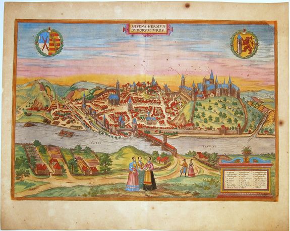
A fine antique copper engraved bird's-eye view of Meissen by Braun and Hogenberg, with key to locations and local costumes in the foreground. From: 'Civitates Orbis Terrarum', ... Part 2, Köln, 1575.
CARTOUCHE: Misena, city of the Hermunduri.
COMMENTARY BY BRAUN: "This city is surrounded by very many rivers, to the east flows the Elbe, to the south the Triebisch, to the west are the mountains, to the north the Meisse, after which the city is said to be named.
The city is well-situated in its surroundings, the navigable rivers, the mountains and the healthy air. Around the city there is a good land to grow grain, fertile vineyards on the hillsides and without doubt the mountains are not without ore, for one mile away, up the Elbe, is Scharfenberg, where silver and lead ore are mined."
The plate of Meissen is a skilful combination of side view and bird's-eye view, looking across the Elbe from the northeast. Meissen grew up around the castle, built by Emperor Henry I around AD 929, and was granted a municipal charter at the end of the 12th century.
From 1471 onwards, the castle complex (21) was reconstructed as the residence of the Saxon electors on the northeast corner of the Domberg (Cathedral Hill).
Meissen cathedral is a Gothic hall church begun c. 1270; in 1413 a bolt of lightning destroyed its west towers (18), which were replaced only in the 20th century (Taschen).
The engraving is made after a woodcut of Münster's Cosmographia, 1572.
The 'Civitates Orbis Terrarum', or the "Braun & Hogenberg", is a six-volume town atlas and the greatest book of town views and plans ever published: 363 engravings, sometimes beautifully colored. It was one of the best-selling works in the last quarter of the 16th century. Georg Braun wrote the text accompanying the plans and views on the verso.
A large number of the plates were engraved after the original drawings of Joris Hoefnagel (1542-1600), who was a professional artist. The first volume was published in Latin in 1572, the sixth volume in 1617. Frans Hogenberg created the tables for volumes I through IV, and Simon van den Neuwel created those for volumes V and VI.
Other contributors were cartographer Daniel Freese, and Heinrich Rantzau. Works by Jacob van Deventer, Sebastian Münster, and Johannes Stumpf were also used. Translations appeared in German and French.
Reference: Van der Krogt 4, 41:1.2
FAQ - Guarantee - Shipping
Rarepapersales has been discontinued.
You can now bid on old maps on the Liveauctioneers platform.These auctions are hosted by NewWorldCartographic from Chicago.
Paulus Swaen keeps selling their maps on its own platform www.swaen.com