Lot #: 85501
Listing ID: #22201 has been added to your wishlist.
USA, États-Unis de l'Amérique septentrionale avec les Isles Royale, de Terre Neuve, de St. Jean, l'Acadie &c. 1785. . . |
||||||||||||||||||||
|
||||||||||||||||||||
|
|
||||||||||||||||||||
|
|
Views: 259
|
|||||||||||||||||||
Description
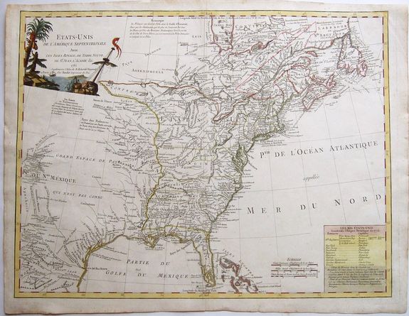
A 1785 map of the United States with alternative state names proposed by Thomas Jefferson [Silvania, Michigania, Chersonesus, Arsenistpia, Metropotamia, Illinoia, Saratoga, Washington, Polypotamia, and Pelisypia], and the first map to name Michigan as a body of land! First edition, first state.
This important and rare original hand colored copper-plate map of the United States (Etats-Unis De L Amerique) was published by the French printer Antoine Boudet (1715 - 1787) for the supplement of de Vaugondys 'Atlas Universal.'
This map is pivotal to the formation of the United States of America. The map is the first to describe what is know as the Jeffersonian Ordinance, showing the new international borders of the fledgling United States, the inclusion of the original 13 states in the bottom right text box (the first map to do so) along with the inclusion of Michigan, ratified under the Treaty of Paris in 1783.
This handsome map covers the newly created United States and extends to take in much of the Louisiana Territory and part of New Mexico. Detail along the Rio del Norte includes Taos and Santa Fe. It also extends to show parts of eastern Canada and the Bahamas.
It shows the original thirteen states with the southern states' western boundaries along the Mississippi River. It identifies many Indian villages and tribal territory. There are extensive notes throughout regarding early explorers such as De Soto and La Salle, Indian nations, forts and other points of early interest.
One of the most intriguing features of the map is the text block, which lists the original 13 states with their capitals and also ten new states proposed in the Jeffersonian Ordinance of 1784
The successor to De Vaugondy, Charles Francois Delamarche (1740 - 1817) was a known correspondent to Thomas Jefferson and along with the printer Boudet would have played an important part in the publication of this map. The Ordinance of 1784 was a plan to outline the new territories and states, that would eventually make up the foundation of the United States, ratified by the Treaty of Paris.
Given that this map was engraved in 1785 or possibly earlier and that Delamarche was a friend of Jefferson, it is not a stretch to believe that he was one of the first, if not the first, to map the new country of the United States.
Reference: Karpinski (MI) #CIII; McCorkle #785.5; Pedley p. 227; Seller & Van Ee 761.
FAQ - Guarantee - Shipping
Rarepapersales has been discontinued.
You can now bid on old maps on the Liveauctioneers platform.These auctions are hosted by NewWorldCartographic from Chicago.
Paulus Swaen keeps selling their maps on its own platform www.swaen.com