Lot #: 95967
Listing ID: #26320 has been added to your wishlist.
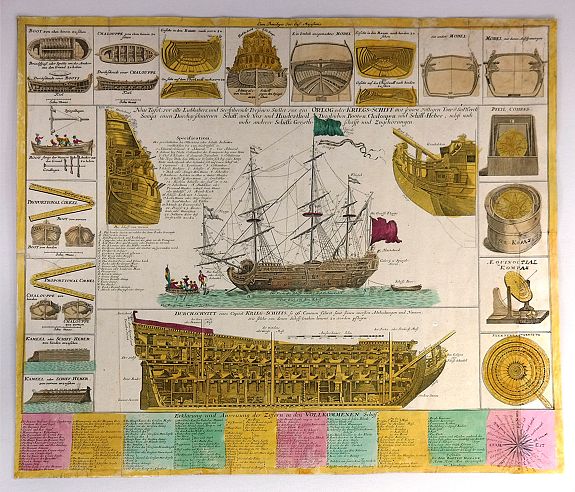
Neue Tafel vor alle Liebhabers und See-fahrende Personen Stellet vor ein Orlog oder Kriegs-Schiff mit seinen volligen Tow & Seilwerck Sampt einen Durchgeschnittnen Schiff... |
||||||||||||||||||||
|
||||||||||||||||||||
|
|
||||||||||||||||||||
|
Selling price: $700
Sold in 2016 |
Views: 176
|
|||||||||||||||||||
Description
Interesting engraving of a warship (a three-masted, 96-gun man-o-war) at anchor, illustrating every aspect of its design and construction.
Beneath the main illustration is a highly detailed cross-section of the interior, down to staircases, barrels in storage areas, and the cannons pointing out of the ship.
The main drawings are surrounded by 17 vignettes of the ribbing and planking, dry docks, and nautical navigational equipment, including different types of compasses.
The title describes it as a "new plate presented to all seafaring people." A key in the lower margin identifies over 150 parts of the ship and rigging. You could construct your own model from these drawings. A compass rose divided into 32 segments decorates the lower right corner.
This print was included in some editions of Homann's “Neuer Atlas…über die Gantze Welt”, which included maps of various parts of the world and city plans by various cartographers and astronomical plates by Johann Gabriel Doppelmayr. Various editions of the atlas were issued between 1712 and around 1730.
Johann Baptist Homann, (1664–1724), a former Dominican monk, became a celebrated cartographer of the 18th century in Nuremberg, Germany, producing maps and celestial charts (generally in atlases) and globes of high quality both in their geographic accuracy and aesthetic appeal.
According to map expert R.V. Tooley: "The most important and prolific map-makers in Germany in the 18th century was the Homann family (1702-1813). The family, located in Nuremberg, was known a Homann Heirs".
Reference: Tooley, R.V. Maps and Map-Makers. New York: Bonanza Books, 1949. p. 27.