Lot #: 42117
Listing ID: #34429 has been removed from your wishlist.
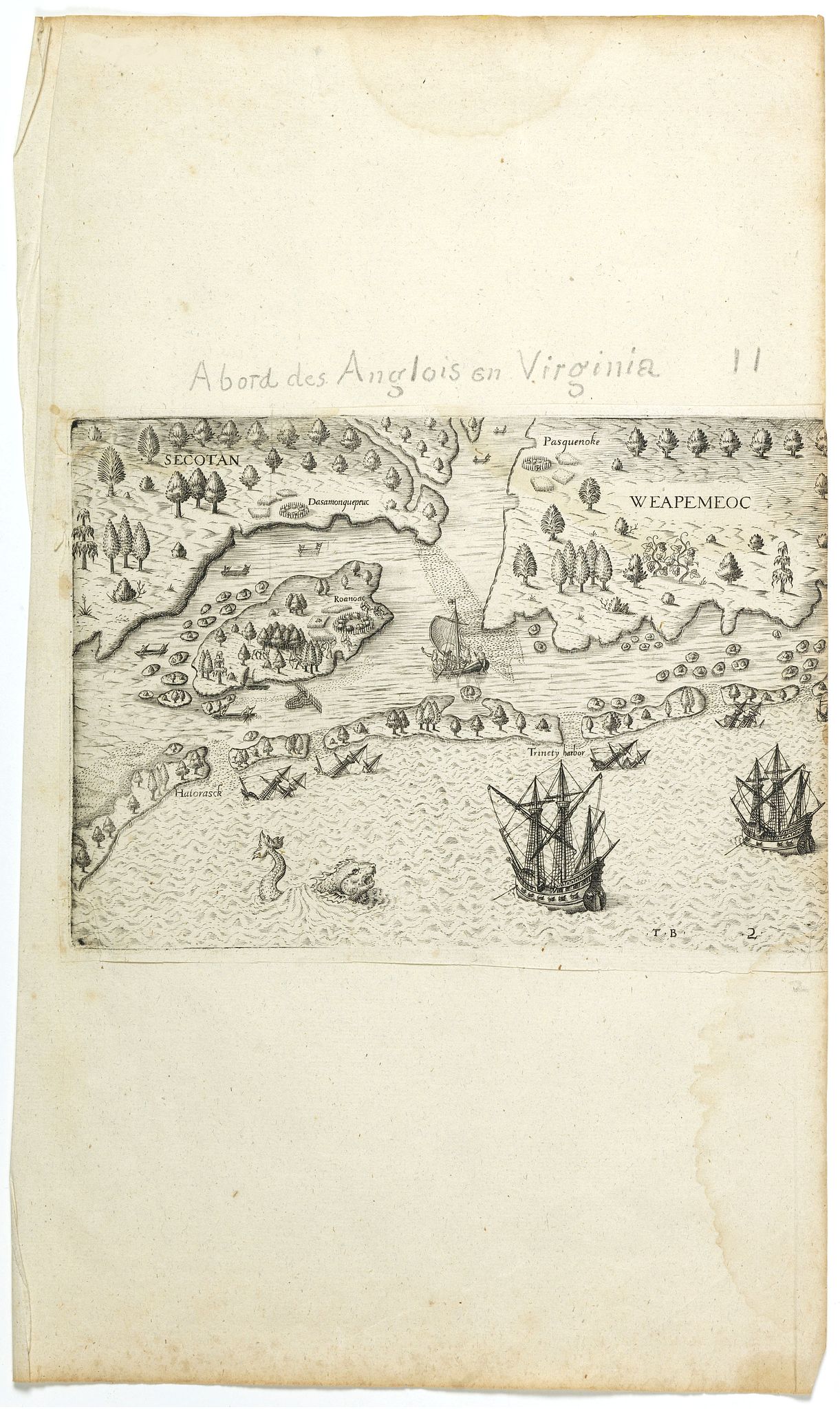
[The Englishmen's arrival in Virginia with Roanoke Colony - Carolina Coastline] No title. |
||||||||||||||||||||
|
||||||||||||||||||||
|
|
||||||||||||||||||||
|
Selling price: $285
Sold in 2018 |
Views: 305
|
|||||||||||||||||||
Description
Map showing the coast of Virginia with many islands just off the mainland, two Native territories, Secotan and Weapemeoc, and the Native community of Roanoak on an island at the mouth of a river. Engraved by Theodor de Bry after a watercolor by John White.
The plate represents the coast of North Carolina, oriented to the west, showing part of Pamlico Sound, Roanoke Island, the mouth of Albemarle Sound and the Alligator River, and part of Currituck Sound with the Carolina Outer Banks, divided into six islands.
The mainland, at the top, on the left, is named SECOTAN with, on the shore, an enclosed Indian village, Dasamonquepeuc, cornfields and conventionalized trees. The other side of Albemarle Sound, top right, is named WEAPEMEOC, with an enclosed village, Pasquenoke, near the water's ed ge, fields of maize and similar trees with the addition of grapevines. In the center, left, Roanoke Island has an enclosed village, Roanoac, with maize fields at the right-hand end (north-east).
Indians with bows and arrows are shown emerging from the village against an attacking party, and further to the left, among the trees, which are shown over much of the island, is a deer being stalked by an Indian with bow and arrow. Below, a fish-weir extends into the sound.
Numerous small islands are shown off the upper and left coastline (south shore) of Roanoke, and on the sounds are a number of fishing canoes (several are also seen in Albemarle Sound). A shoal is indicated across the mouth of Albemarle Sound and extends into Currituck Sound. Along the edge of the shoal an English pinnace is shown making its way towards Roanoke Island. She has three pairs of oars and a steering oar, a flag with the cross of St George at the masthead, while perhaps ten figures are shown standing and seated.
The islands of the Carolina Outer Banks extend across the middle of the engraving (from south to north), the name Hatorasck being given to the first island or the first opening. All five openings are marked by shoals, the third being named Trinety harbor. The islands are shown as moderately well-wooded.
Conventionalized wrecks (bowsprit and masts appearing above the water) are shown off each of the five inlets through the Banks. Along the bottom, out at sea, a sea monster is shown and two English ships at anchor, the larger on the left.