Browse Listings in Antique Maps > Map Types
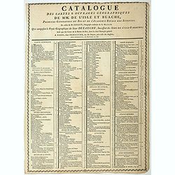
Catalogue des cartes & ouvrages geographiques de MM. DE L'ISLE ET BUACHE
Broad side sheet with on both side a listing of the geographical works of Buache. The sheet also lists the prices of the maps and atlases. The most expensive being the &q...
Place & Date: Paris, ca. 1780
Selling price: $150
Sold in 2023
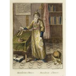
Mandarino Chinese. - Mandarin Chinois.
Hand-colored engraving by Teodoro Viero (1740-1819), a famous venetian 18th century artist who engraved and published numerous plates after artists including Tiepolo, Gra...
Place & Date: Venice, ca. 1781
Selling price: $300
Sold in 2008

Frontispiece to Anderson's Large Folio Edition of the Whole of Captn Cook's Voyages &c. Complete.
Excellent copper engraved portrait of Captain James Cook set within a decorative frame. With the dates of his three voyages below and with the text line: He was Born at ...
Place & Date: London, 1781
Selling price: $75
Sold in 2016

Captain James Cook.
Copper engraved portrait of James Cook (1728-1779), published in "A new, authentic, and complete collection of voyages round the world" published in London by A...
Place & Date: London, Alexander Hogg, 1781
Selling price: $200
Sold in 2021
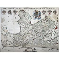
T Hoogh-Heemraetschap van de Uytwaterende Sluysen in Kennemerlant ende West-Frieslant’
A very large format wall map of the province of North Holland made and published for the district water board of Kennemerland and West Friesland, on four leaves, combined...
Place & Date: Amsterdam, 1781
Selling price: $1100
Sold in 2021
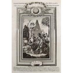
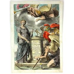
(Frontispiece to Millar's New & Universal System of Geography.)
Fine title page showing Neptune and Britannia among several other figures. With lovely details including a globe, a pyramid, fruits, etc.
Place & Date: London, 1782
Selling price: $19
Sold in 2017
![[Title page] Atlas Général A l'Usage des Collèges Et Maisons d'Education Adapté aux Différents ouvrages de Géographie?](/uploads/cache/17233-250x250.jpg)
[Title page] Atlas Général A l'Usage des Collèges Et Maisons d'Education Adapté aux Différents ouvrages de Géographie?
Rare title page published by Monhare for his Atlas Général a l'usage des colleges et maisons d'education.. Louis Joseph Mondhare published several smaller atlases and r...
Place & Date: Paris, 1783
Selling price: $140
Sold

Atlas Moderne ou collection des cartes sur toutes les parties du Globe Terrestre..
Jean Lattré, Paris-based engraver and publisher. Worked with Robert de Vaugondy, J. Janvier and R. Bonne. " Atlas Monderne', 1771, 1783 , 1793. A decorative frontis...
Place & Date: Paris, 1783
Selling price: $150
Sold
Atlas Universel dressé sur les meilleures cartes modernes.
Title page of the Atlas Universel dressé sur les meilleures cartes modernes . Title is set in an allegorical scene of mythological figures.The address has been changed ...
Place & Date: Venice, 1784
Selling price: $150
Sold in 2008

(Frontispiece to Walpoole's New & Complete British Traveller.)
An interesting title page showing a globe and a map. Below with text: "This Superbly Elegant Frontispiece Represents Britannia (attended by Prudence, Justice, Temper...
Place & Date: London, 1784
Selling price: $17
Sold in 2017
(Frontispiece to Walpoole's New & Complete British Traveller.)
Interesting title page showing a globe and a map. Below with text: "This Superbly Elegant Frontispiece Represents Britannia (attended by Prudence, Justice, Temperanc...
Place & Date: London, 1784
Selling price: $73
Sold in 2017

Casparus Barleus
Attractive portrait of the author of 'Rerum in Brasilia Gestarum Historia, 1647', with large scale map. Oversaw the maps in Herrera's Historia General, 1622.
Place & Date: Amsterdam, 1786
Selling price: $70
Sold in 2008
(Title page) Atlas General et Elementaire Pour L'Etude de la Geographie et de L'Histoire Moderne
A fine allegorical frontispiece from Sr. Desnos's "Atlas General et Elementaire Pour L'Etude de la Geographie et de L'Histoire Moderne." Published in Paris in 1...
Place & Date: Paris, 1786
Selling price: $205
Sold in 2016
Frontispice de l'Enceclopedie.
Frontispice of Rigobert Bonne's 'Atlas Enceclopédie.
Place & Date: Paris, 1787
Selling price: $90
Sold
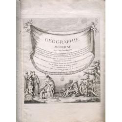
(Title page) Geographie Moderne Avec Une Introduction
Title Page plus additional page of description.
Place & Date: Paris, 1767-1787
Selling price: $100
Sold in 2015

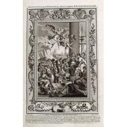
Columbus Presenting an Account of His Discovery of America to the King and Queen of Spain.
Christopher Colombus (1451-1506) depicted on his knee presenting documents to Carlos II King of Spain after his return after his third voyage in 1498. From “Bankes's N...
Place & Date: London, 1787
Selling price: $109
Sold in 2016
![[Title page] Allgemeiner Grosser Atlass . . .](/uploads/cache/45001-250x250.jpg)
[Title page] Allgemeiner Grosser Atlass . . .
Title page of Grosser Atlass. Franz Anton Schraemble (1751-1803), was a Austrian cartographer. He is well known for his "Allgemeiner deutscher Atlas aller Länder&qu...
Place & Date: Vienna, ca. 1788
Selling price: $80
Sold in 2023

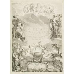
(Title page) Atlas Géographique et Universel par Guil.DeLisle et Phil. Buache Premiers Géographes De l'Académie des Sciences..
Dramatic title page engraved for Atlas Géographique.. published by Dezauche, as successors to De l'Isle & Buache.
Place & Date: Paris, 1789
Selling price: $150
Sold in 2013
![[Titlepage] Grand Atlas d'Allemagne en LXXXI Feuilles, dedié a Sa Majesté Joseph II, Empereur des Romains.](/uploads/cache/38077-250x250.jpg)
[Titlepage] Grand Atlas d'Allemagne en LXXXI Feuilles, dedié a Sa Majesté Joseph II, Empereur des Romains.
Very decorative title page showing underneath the title the rising sun with a military camp next to a city and in the right foreground emperor Joseph II . With officers, ...
Place & Date: Frankfurt am Main, 1789
Selling price: $125
Sold
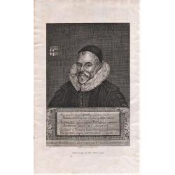
Portrait of: William Camden from Britannia.
Lettered in background "Giulielm Camden Clarenti / Praelecturae Historicae Fundator Munific / Pondere non numero". With six lines of Latin on plaque, beginning ...
Place & Date: London, 1789
Selling price: $60
Sold in 2018
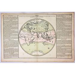
Zones.
A circular map of the Eastern Hemisphere, depicting the zones of the earth, including Torid, Temper and Glacial.To the left and right of the map is French text with remar...
Place & Date: Paris, 1790
Selling price: $28
Sold in 2018
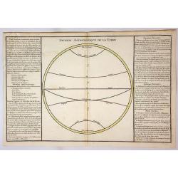
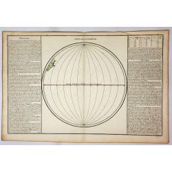
Division Astronomique de la Terre.
An empty circular map of a hemisphere depicting the equator and zones including Tropic, Cancer, Tropic and Capricorn. To the left and right of the map is French text with...
Place & Date: Paris, 1790
Selling price: $8
Sold in 2018
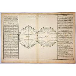
De la Longitude et de la Latitude.
Two empty circular maps of hemispheres depicting the Longitude and Latitude. To the left and right of the map is French text with remarks and descriptions of the map. It ...
Place & Date: Paris, 1790
Selling price: $1
Sold in 2018
Suite de Longitude.
A circular map depicting the Equator and lines of Longitude. To the left and right of the map is French text with remarks and descriptions of the map. It is from “Geogr...
Place & Date: Paris, 1790
Selling price: $17
Sold in 2019
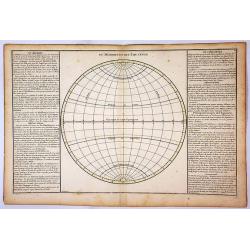
Du Meridien et de L'Equateur.
A circular map depicting the Equator and Tropic of Cancer and Capricorn. To the left and right of the map is French text with remarks and descriptions of the map. It is f...
Place & Date: Paris, 1790
Selling price: $20
Sold in 2018
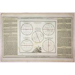
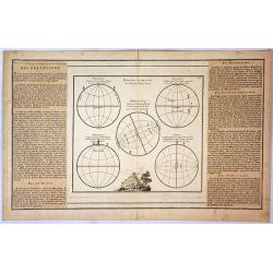
Lecon Methodique et Elementaire.
Five circular maps showing the position of various people on the earth. The map features a vignette at the centre bottom. To the left and right of the map is French text ...
Place & Date: Paris, 1790
Selling price: $8
Sold in 2018
Position Respective des Peuples de la Terre.
Five circular maps showing the position of various people on the earth. The map features a vignette at the centre bottom. To the left and right of the map is French text ...
Place & Date: Paris, 1790
Selling price: $50
Sold in 2019
![[Title page] Grosser Deutscher Atlas.](/uploads/cache/11950-250x250.jpg)
[Title page] Grosser Deutscher Atlas.
Very decorative title page from the Grosser Deutscher Atlas published by Franz Joh. Jos. Von Reilly. The engraver was Karl Schütz, after a design by Vinzenz Georg Kining...
Place & Date: Vienna 1791
Selling price: $300
Sold

Petrus Plancius.
A portrait of the famous Dutch cartographer.
Place & Date: Amsterdam, 1791
Selling price: $90
Sold
![[Title page] Atlas Nationale Portatif de la France. . .](/uploads/cache/31044-250x250.jpg)
[Title page] Atlas Nationale Portatif de la France. . .
Charming title page of an uncommon atlas of France. The text is set in a white area in the shape of France and Corsica, surrounded by leaves and flowers and a large angel...
Place & Date: Paris, 1791
Selling price: $20
Sold in 2016
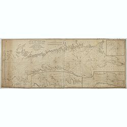
New and correct chart of the Gulf of Finland from the Russian and Swedish surveys Regulated and Ascertained by celestial observations. . .
Large scale blue-backed chart with three insets, . The Bay of Revel. The entrance of Cronstadt. The entrances to Fredrichstamn with Afpo Isles. The main chart has Saint P...
Place & Date: London, Liverpool, 1791
Selling price: $250
Sold in 2023
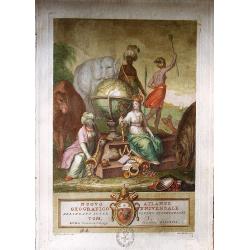
Nuovo Atlante Geografico Universale delineato sulle ultime osservazioni.
A superb frontispiece from an uncommon atlas, the 'Nuovo Atlante Geografico Universale', by Giovanni Maria Cassini, published in1792. He was a geographer and a cartograph...
Place & Date: Rome, 1792
Selling price: $475
Sold in 2016
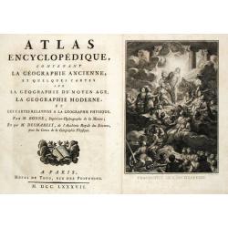
GÉOGRAPHIE MODERNE
Decorative title page showing sailing ships, puttis with coat of arms, different figures one holding a map another sitting with an Indian.
Place & Date: Paris 1793
Selling price: $40
Sold
![[Title page] Raccolta di sessanta piu belle vestiture..](/uploads/cache/11832-250x250.jpg)
[Title page] Raccolta di sessanta piu belle vestiture..
Title page from Raccolta di sessanta piu belle vestiture... Very fine, typical Italian title page with putti, etc. Uncommon and decorative.
Place & Date: Napels, 1793
Selling price: $65
Sold in 2018
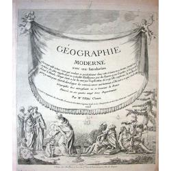
![[Title page for] Géographie moderne avec une introduction. . .](/uploads/cache/47949-250x250.jpg)
[Title page for] Géographie moderne avec une introduction. . .
Engraved title page from Jean Baptiste Louis Clouet (1730-1790) influential "Géographie Moderne" first published in 1767 and reissued in several editions well ...
Place & Date: Paris, 1793
Selling price: $25
Sold in 2022
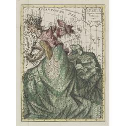
Europa volgens de nieuwste verdeeling.
Uncommon curiosity, depicting Europe as a regal queen but with an interesting twist and political commentary. This anti-Napoleonic image demotes Europa from a virgin-quee...
Place & Date: Haarlem, 1794
Selling price: $800
Sold in 2009
Groessen und Bevoelkerungs Karte von Europa..
A thematic presentation of the sizes of the European countries and their number of inhabitants. From the Grosser Deutscher Atlas published by Franz Joh. Jos. Von Reilly. ...
Place & Date: Vienna 1794
Selling price: $130
Sold in 2012
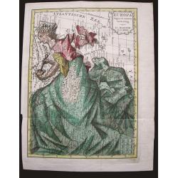
Europa volgens de nieuwste verdeeling.
Uncommon curiosity, depicting Europe as a regal queen but with an interesting twist and political commentary. This anti-Napoleonic image demotes Europa from a virgin-quee...
Place & Date: Haarlem, 1794
Selling price: $350
Sold in 2015
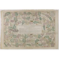
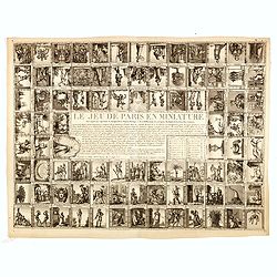
Jeu Géographique de la République française présenté à la Convention Nationale.
Educational game directed by a former professor of geography. It was intended to promote the new French departments, each represented on one of the 83 boxes with its capi...
Place & Date: Paris, Basset, ca. 1795
Selling price: $1300
Sold in 2016

Atlas Universel Par ROBERT Geographe et par Robert de Vaugondy. . .
A copper engraved title page origin: de Vaugondy's Atlas Universal. Signed by the engraver Jean Charles Baquoy at lower right. A very elaborate title page with the person...
Place & Date: Paris, 1795
Selling price: $150
Sold in 2018
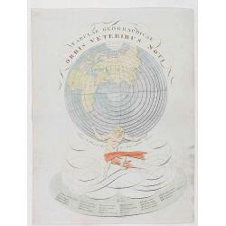
Tabulae Geographicae Orbis Veteribus noti.
Rare title page of an atlas with Atlas carrying the world. Copper engraving by Franz Reißer published in: "Tabulae Geographicae Orbis Veteribus noti". Title en...
Place & Date: Vienna, ca. 1795
Selling price: $100
Sold in 2020

(Title page) Voyage pittoresque de la France ouvrage national dédié au roi. Frontispice pour la province du Dauphiné.
Beautiful title page for the region of the Dauphine. Print showing 3 women with a baby, putti and the royal arms (3 fleurs de lys).From "Description générale et pa...
Place & Date: Paris, Lamy, 1781-1796
Selling price: $120
Sold in 2012
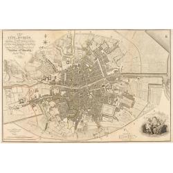
Plan of the City of Dublin Surveyed for Use of the Division of Justices, to Which have been Added Plans of the Canal Harbor and its Junction with the Grand Canal...
This is a rare separately issued map of Dublin, Ireland as it was at the end of what can be considered a rather prosperous century for the nation's capital and largest ci...
Place & Date: London, 1797
Selling price: $1600
Sold in 2023

(Title page) Campi phlegraei ou observations sur les volcans des deux Siciles, . . .
Etched and mezzotint title with in the center an eruption of volcano in Sicily.William Hamilton, an English diplomat in Naples to the Kingdom of The Two Sicily's, was a g...
Place & Date: Paris, Lamy, 1799
Selling price: $50
Sold in 2022
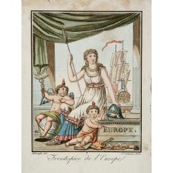
Frontispice de l'Europe.
Decorative title page with heraldic figures and large ship with French flag. One putti sitting on a globe and holding the scepter of Mercury.
Place & Date: Paris, 1800
Selling price: $140
Sold in 2014

Allgemeiner Grosser Atlas, 1800.
Franz Anton Schraemble (1751-1803), Austrian cartographer. Allgemeiner deutscher Atlas aller Länder, 1786-94, Allgemeiner Grosser Atlas, 1800.
Place & Date: Wien, 1800
Selling price: $275
Sold
![[Titlepage] Atlas Maritime.](/uploads/cache/05113-250x250.jpg)
[Titlepage] Atlas Maritime.
Uncommon title page from "Atlas Maritime" by Ivone Gravier active in Genoa. In lower margin "Chez Yves Gravier Libraire a Génes".The engraving depict...
Place & Date: Genoa, 1801
Selling price: $350
Sold in 2011
![[Title page] Nuovo Atlante geografico universale. . .](/uploads/cache/04049-250x250.jpg)
[Title page] Nuovo Atlante geografico universale. . .
Attractively engraved frontispiece. Atlas carries the world on his shoulders, four figures representing the continents, while Europe sits enthroned in the foreground.Titl...
Place & Date: Rome, 1792 - 1801
Selling price: $250
Sold in 2019
![[Title page] Atlas de la République française ..](/uploads/cache/17247-250x250.jpg)
[Title page] Atlas de la République française ..
Title page from, Atlas de la République Française composé de 102 feuilles Indiquant les Départements, les arrondissements Communaux, Les Justices de Paix Actuelles, l...
Place & Date: Paris, 1802
Selling price: $35
Sold
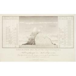
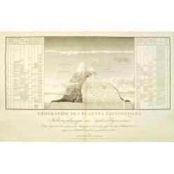
Géographie des Plantes Equinoxiales - Tableau physique des Andes et pays voisins..
''Physical Portrait of the Andes and adjacent lands'', around the Chimborazo and Cotopaxi volcanoes, in Equador.With local vegetation illustrates pictorially on the left ...
Place & Date: Paris, 1805
Selling price: $750
Sold in 2009
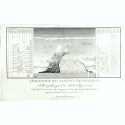
Géographie des Plantes Equinoxiales - Tableau physique des Andes et pays voisins..
"Physical Portrait of the Andes and adjacent lands", organized around the Chimborazo and Cotopaxi volcanoes, in Ecuador.With local vegetation illustrates pictor...
Place & Date: Paris, 1805
Selling price: $1250
Sold in 2014
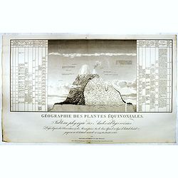
Géographie des Plantes Equinoxiales - Tableau physique des Andes et pays voisins..
"Physical Portrait of the Andes and adjacent lands", organized around the Chimborazo and Cotopaxi volcanoes, in Ecuador.With local vegetation illustrates pictor...
Place & Date: Paris, 1805
Selling price: $850
Sold in 2015
Géographie des Plantes Equinoxiales - Tableau physique des Andes et pays voisins. . .
"Physical Portrait of the Andes and adjacent lands", organized around the Chimborazo and Cotopaxi volcanoes, in Ecuador.With local vegetation illustrates pictor...
Place & Date: Paris, 1805
Selling price: $1250
Sold in 2018
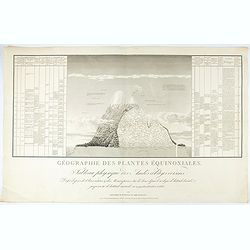
Géographie des Plantes Equinoxiales - Tableau physique des Andes et pays voisins..
"Physical Portrait of the Andes and adjacent lands", organized around the Chimborazo and Cotopaxi volcanoes, in Ecuador.With local vegetation illustrates pictor...
Place & Date: Paris, 1805
Selling price: $1250
Sold in 2021
![[Titlepage] Atlas Methodicus explorandis juvenum profectibus in Studio Geographico..](/uploads/cache/22365-250x250.jpg)
[Titlepage] Atlas Methodicus explorandis juvenum profectibus in Studio Geographico..
Taken from title page from Atlas methodicus explorandis juvenum profectibus in studio geographico ad methodum Hubnerianam accommodatus, a Johanne Baptista Homanno, Sacrae...
Place & Date: Nuremberg 1807
Selling price: $200
Sold
![[Titlepage] Atlas Novus Terrarum orbis Imperia..](/uploads/cache/41744-250x250.jpg)
[Titlepage] Atlas Novus Terrarum orbis Imperia..
The decorative title page from Atlas Novus printed by Johann Ernst Udelbulner. Large elaborately engraved sheet with numerous allegorical figures. A large globe, showing ...
Place & Date: Nuremberg 1807
Selling price: $90
Sold in 2018
![[Titlepage] Atlas Novus Terrarum orbis Imperia..](/uploads/cache/45629-250x250.jpg)
[Titlepage] Atlas Novus Terrarum orbis Imperia..
The decorative title page from Atlas Novus printed by Johann Ernst Udelbulner. Large elaborately engraved sheet with numerous allegorical figures. A large globe, showing ...
Place & Date: Nuremberg 1807
Selling price: $210
Sold in 2020
![[Part of a wall map of Hungary].](/uploads/cache/42560-250x250.jpg)
[Part of a wall map of Hungary].
The Upper left corner of the large folding wall map of Hungary was prepared by Ignac Müller and published first in 1769. The map was made for official use and was kept ...
Place & Date: Vienna, T.Mollo, 1769 - 1807
Selling price: $75
Sold in 2023
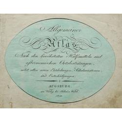
![[Title page] Allgemeiner Atlas Nach den bewährsten Hülfsmitteln und astronomischen Ortsbestimungen](/uploads/cache/29407-250x250.jpg)
[Title page] Allgemeiner Atlas Nach den bewährsten Hülfsmitteln und astronomischen Ortsbestimungen
Title page by Johannes Walch from his rare Allgemeiner Atlas Nach den bewährsten Hülfsmitteln und astronomischen Ortsbestimungen…, edition of 1812.Johann Walch (1757-...
Place & Date: Augsburg, 1812
Selling price: $30
Sold in 2017
Allgemeiner Atlas Nach den bewährsten Hülfsmitteln und astronomischen Ortsbestimungen. . .
Title page by Johannes Walch from his rare Allgemeiner Atlas Nach den bewährsten Hülfsmitteln und astronomischen Ortsbestimungen…, the edition of 1812.
Place & Date: Augsburg, 1812
Selling price: $50
Sold in 2020

Journal de la Belgique. Orbis terrarum
Among the most interesting decorative works of cartography is a series of arresting maps showing The Netherlands and Belgium in the shape of a lion. This wonderful, minia...
Place & Date: Brussels, 1815
Selling price: $175
Sold in 2008
![[No title] From "Journal de la Belgique" Jeudi, 27 Février 1817.](/uploads/cache/22264-250x250.jpg)
[No title] From "Journal de la Belgique" Jeudi, 27 Février 1817.
Lion (45x35mm.) rampant facing right with shield in the right forepaw. In the shield: L'Union fait la Force. 2 vessels and a star are present in the sea. 2 pages of Frenc...
Place & Date: Bruxelles? 1817
Selling price: $525
Sold
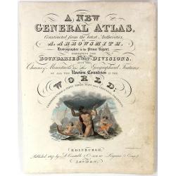
Frontispiece - A New General Atlas
A fine, hand-colored frontispiece for Arrowsmith's "A NEW GENERAL ATLAS", published In 1817 by A. Constable & Co. in London.Map engraved by Charles Heath.
Place & Date: London, 1817
Selling price: $32
Sold in 2016
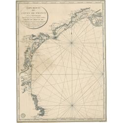
Carte réduite des côtes de France sur la Méditerranée
This masterful and attractive sea chart of the southern coast of France was created by order of the King of France for the Royal Nautical Depository (Dépôt), and bears ...
Place & Date: Paris, 1817
Selling price: $100
Sold in 2023
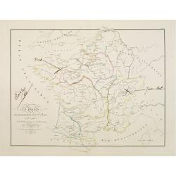
La France au commencement de la 3.eme Race..
UNIQUE: with paragraph of the creator of the map Adrien Hubert Brué (1786-1832). The map is a proof with color corrections marked in brown ink by Adrien Hubert Brué.
Place & Date: Paris 1820
Selling price: $180
Sold in 2010
A fine collection of 10 printed game boads, some with cartographical subjects.
The most common game-play set up, used in board games even today, comes from an Italian game known as Goose, which originated in the late 1500s. This game, popular all ov...
Place & Date: Several publishers, 1660 - 1820
Selling price: $8600
Sold in 2014
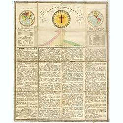
Chart of the rise & progress of christianity.
A very unusual folding sheet with in top double hemisphere hand colored world map with a note saying : In the map of the World, those parts colored RED, are inhabited by...
Place & Date: London, after 1823
Selling price: $550
Sold in 2016
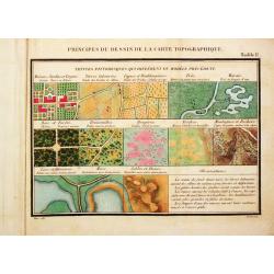
Principes du Dessin et du Lavis de la Carte Topographique.
8vo, oblong, 92 pp, leather (a bit chafed), back gold-stamped. With 3 folding tables and 9 (8 hand-colored) plates.Important instruction book on the drawing and coloring ...
Place & Date: Paris, 1825
Selling price: $1500
Sold
![[Map of Martrimony]](/uploads/cache/42145-250x250.jpg)
[Map of Martrimony]
A rare anonymous early 19th century manuscript map of Matrimony. Among the many names are Rocks of jealousy, Sea of flirtation, P. of proposal, Kingdom of suspense, Land ...
Place & Date: ca. 1800 - 1825
Selling price: $500
Sold in 2019
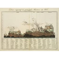
Tableau comparatif des principales hauteurs du globe. D'apres A.M. Perrot.
Lithography depicting comparative front views of the world's tallest mountains, divided in adjacent sections according to the countries. At the bottom an exhaustive key l...
Place & Date: Brussels 1827
Selling price: $250
Sold
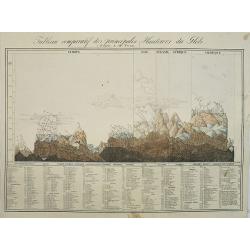
Tableau comparatif des principales hauteurs du globe. D'apres A.M. Perrot.
Lithography depicting comparative front views of the world's tallest mountains, divided in adjacent sections according to the countries. At the bottom an exhaustive key l...
Place & Date: Brussels, 1827
Selling price: $100
Sold in 2009
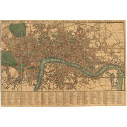
Tegg's New Plan of London, &c. with 360 References to the Principal Streets, &c. 1827.
This is a fine example of an early 19th-century folding map tailored for travelers navigating London, highlighting 260 principal streets. First released by Thomas Tegg of...
Place & Date: London 1823 / 1827
Selling price: $350
Sold in 2024
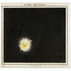
B.C. 2348. The deluge.
Plate from "An historical atlas: in a series of maps of the world as known at different periods constructed upon a uniform scale and colored according to the politic...
Place & Date: London, 1830
Selling price: $160
Sold in 2020
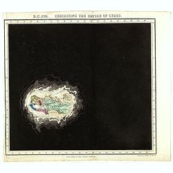
B.C. 529. Exhibiting the Empire of Cyprus.
Plate from An historical atlas: in a series of maps of the world as known at different periods constructed upon an uniform scale and colored according to the political ch...
Place & Date: London, 1830
Selling price: $106
Sold in 2024
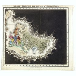
A.D. 1294. Exhibiting the Empire of Kublai Khan.
Plate from An historical atlas: in a series of maps of the world as known at different periods constructed upon an uniform scale and colored according to the political ch...
Place & Date: London, 1830
Selling price: $100
Sold in 2020
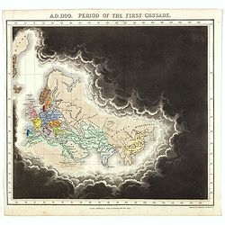
A.D. 1100. Period of the first crusade.
Plate from An historical atlas: in a series of maps of the world as known at different periods constructed upon an uniform scale and colored according to the political ch...
Place & Date: London, 1830
Selling price: $125
Sold in 2023
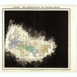
A.D. 476. The dissolution of the Western Empire.
Plate from An historical atlas: in a series of maps of the world as known at different periods constructed upon an uniform scale and colored according to the political ch...
Place & Date: London, 1830
Selling price: $106
Sold in 2024
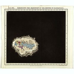
B.C. 301. Exhibiting the partitionof the Empire of Alexander.
Plate from An historical atlas: in a series of maps of the world as known at different periods constructed upon an uniform scale and colored according to the political ch...
Place & Date: London, 1830
Selling price: $120
Sold
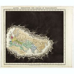
A.D. 814. Exhibiting the Empire of Charlemagne.
Plate from An historical atlas: in a series of maps of the world as known at different periods constructed upon an uniform scale and colored according to the political ch...
Place & Date: London, 1830
Selling price: $106
Sold in 2024
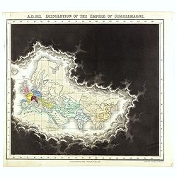
A.D. 912. Dissolution of the Empire of Charlemagne.
Plate from An historical atlas: in a series of maps of the world as known at different periods constructed upon an uniform scale and colored according to the political ch...
Place & Date: London, 1830
Selling price: $100
Sold in 2021