Browse Listings in Antique Maps > Map Types
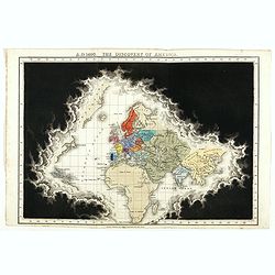
A.D. 1498. The discovery of America.
Plate from An historical atlas: in a series of maps of the world as known at different periods, constructed upon a uniform scale and colored according to the political ch...
Place & Date: London, 1830
Selling price: $300
Sold
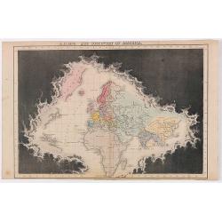
A.D. 1498. The discovery of America.
Plate from An historical atlas: in a series of maps of the world as known at different periods, constructed upon a uniform scale and colored according to the political ch...
Place & Date: London, 1830
Selling price: $50
Sold in 2020
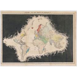
A.D. 1551. At the death of Charles V.
Plate from An historical atlas: in a series of maps of the world as known at different periods, constructed upon an uniform scale and colored according to the political c...
Place & Date: London, 1830
Selling price: $80
Sold in 2020
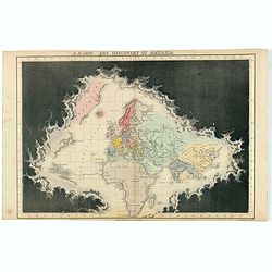
A.D. 1498. The discovery of America.
Plate from "An historical atlas: in a series of maps of the world as known at different periods, constructed upon an uniform scale and colored according to the polit...
Place & Date: London, 1830
Selling price: $85
Sold in 2022

(Title page) Voyage au Pole Sud et dans l'Oceanie. . .
Title page from his first part of "Voyage au Pole Sud et dans l'Oceanie". Dumont d'Urville, Jules-Sébastien-César, 1790-1842. Voyage au Pole Sud et dans l'Oc�...
Place & Date: Paris, Lemercier, 1833
Selling price: $150
Sold in 2012

(Title page) Voyage au Pole Sud et dans l'Oceanie. . .
Title page from his second part of "Voyage au Pole Sud et dans l'Oceanie". Dumont d'Urville, Jules-Sébastien-César, 1790-1842. Voyage au Pole Sud et dans l'Oc...
Place & Date: Paris, Lemercier, 1833
Selling price: $150
Sold in 2012

Queen Victoria - Barclay's Dictionary Frontispiece
A fine frontispiece featuring a young Queen Victoria sitting on her throne. She is surrounded by a ribbon cartouche with "Chorographia Brittanniae" and a crowne...
Place & Date: London, 1836
Selling price: $20
Sold in 2016
![[Title page] Flora's dictionary by Mrs. E.W. Wirt of Virginia.](/uploads/cache/31045-250x250.jpg)
[Title page] Flora's dictionary by Mrs. E.W. Wirt of Virginia.
Charming title page from "Flora's dictionary by Mrs. E.W. Wirt of Virginia. Embellished by miss Ann Wish".Hand-colored lithographic plates after Ann Smith.The w...
Place & Date: Baltimore, Fielding jnr, L.,1837
Selling price: $50
Sold in 2011
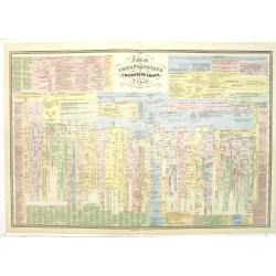
Tableau chronologique de l'histoire de France par P.J Ferrand.
An extensive timetable of France with a wealth of historical information until the year 1811. Prepared by P.J.Ferrand, engraved by Ch. Simon and published by Auguste Loge...
Place & Date: Paris, c.1839
Selling price: $70
Sold in 2020
![[Title page] Les Fleurs.](/uploads/cache/31047-250x250.jpg)
[Title page] Les Fleurs.
Charming title page from Moses Harris (1731–1785) from Moses Harris's 1840 edition of "The Aurelian, A Natural History of English Moths and Butterflies". Acco...
Place & Date: London, 1840
Selling price: $150
Sold in 2015

Captain James Cook.
Fine steel engraved portrait of Captain Cook one of the most famous explorers and cartographers. It is from the original picture by Dance in the Gallery of Greenwich Hosp...
Place & Date: London, 1840
Selling price: $26
Sold in 2017

Coffee cup and plate with map design.
The coffee cup has a map of the eastern part of the globe from Europe up to Asia, including China and Korea with a "Mer de Cor(ée)" for the sea between Japan a...
Place & Date: England, ca.1840
Selling price: $300
Sold in 2018
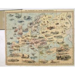
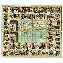
The Travellers or, a Tour Through Europe.
Geographic game, showing a beautiful map of Europe as it does not exist, with the locations of the cities slightly distorted. Prague seems to be North of Dresden and Vien...
Place & Date: London, 1842
Selling price: $1010
Sold in 2013

(Title page) Views on the Nile from Cairo to the second cataract.
Title page drawn on stone by George Moore, from sketches taken in 1832 and 1833 by Owen Jones and the late Jules Goury.The 19th-century Egyptian revival in Britain develo...
Place & Date: London, Graves and Warmsley, 1843
Selling price: $100
Sold in 2021
![[Title page] Voyage pittoresque et archaéologique en Russie.](/uploads/cache/41442-250x250.jpg)
[Title page] Voyage pittoresque et archaéologique en Russie.
Title page of "Voyage pittoresque et archaéologique en Russie" with two joined pages. The first is a letter for a certain "Mathilde" from Anatole Dé...
Place & Date: Paris, 1844
Selling price: $100
Sold in 2018
![[Title page] Voyage pittoresque et archaéologique en Russie.](/uploads/cache/43490-250x250.jpg)
[Title page] Voyage pittoresque et archaéologique en Russie.
Title page of "Voyage pittoresque et archaéologique en Russie" with two joined pages. The first is a letter for a certain "Mathilde" from Anatole Dé...
Place & Date: Paris, 1844
Selling price: $100
Sold in 2021
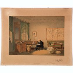
(Alexander von Humboldt in his study)
This rare and charming lithography of Alexander von Humboldt (1769-1859) in his study was made after a water color of his close friend E. Hildebrandt. Printed facsimile c...
Place & Date: Berlin, A. Duncker, 1845
Selling price: $800
Sold in 2015
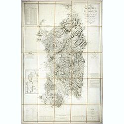
Carta dell isola e regno di Sardegna.
Considered the first map of Sardinia according to modern geodesic methods, it was realized thanks to the work of Alberto Ferrero della Marmora, later assisted by Majo...
Place & Date: Paris and Torino, 1845
Selling price: $500
Sold in 2022
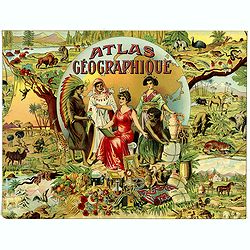
![[Title page] Atlas Illustré destineé à ..](/uploads/cache/08379-250x250.jpg)
[Title page] Atlas Illustré destineé à ..
Fine title page published by Basset, rue de Seine 33, Paris. Included in Atlas Illustré destineé à l'enseignement de la géographie élémentaire 48 cartes par M.M. J....
Place & Date: Paris 1846
Selling price: $10
Sold in 2009
![[Title page] Les Fleurs.](/uploads/cache/31046-250x250.jpg)
[Title page] Les Fleurs.
Charming title page from volume 1 of J.J. Grandville's 'Les Fleurs Animées'. (The Flowers Personified)The book was a masterpiece of botanic illustration, the steel engra...
Place & Date: Paris, Dubuisson, 1847
Selling price: $50
Sold in 2020

Map of the Districts and Countries of Great Japan
This is a spectacular, large format folding map of Japan by Takashiba Ei'San'Yu, dated 1849. The map presents the primary Japanese islands of Kyushu, Honshu, Shikoku and ...
Place & Date: Japan, 1849
Selling price: $800
Sold in 2023
![[Untitled map of the European countries in a playing grid].](/uploads/cache/32645-250x250.jpg)
[Untitled map of the European countries in a playing grid].
Small, accurate lithographed maps of Europe and Asia, embedded in a square playing grid formed by 100 cells.The 11 cells contain the profile of or a reference to a empero...
Place & Date: France, ca. 1850
Selling price: $75
Sold in 2015

Sir Francis Drake O.B. 1596
A fine steel engraving by Freeman from an original painting. It was published by Fullerton & Co. in Glasgow around 1850.Sir Francis Drake, circa 1540-1596, was an Eng...
Place & Date: Glasgow, ca. 1850
Selling price: $10
Sold in 2017
![[Title page] Atlas National Illustré des 86 Départements et des Possessions de la France . . .](/uploads/cache/29518-250x250.jpg)
[Title page] Atlas National Illustré des 86 Départements et des Possessions de la France . . .
Frontispiece of the
Place & Date: Paris, A. Combette, 1851
Selling price: $30
Sold in 2010
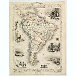
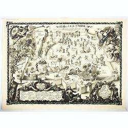
South America.
This is John Tallis’ pretty map of South America. The map is surrounded by a number of topical steel engraved vignettes and the whole is surrounded by a decorative vine...
Place & Date: London, 1851
Selling price: $50
Sold in 2023

Geographische Wercke aus dem Verlag von Justus Perthes in Gotha. Januar 1852.
A very rare publicity leaflet for atlases published by Justus Perthes in 1852. This leaflet is very valuable as it gives in detail the different atlasses published in 185...
Place & Date: Gotha, 1852
Selling price: $150
Sold
![[Title page]. Atlas National Illustré des 86 Départements et des Possessions de la France . . .](/uploads/cache/27077-250x250.jpg)
[Title page]. Atlas National Illustré des 86 Départements et des Possessions de la France . . .
Frontispiece of the
Place & Date: Paris, A. Combette, 1852
Selling price: $50
Sold in 2011
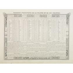
Tableau Statistique de la France et de ses Colonies.
Demographic and geographic statistic chart of France and its colonies.From one of the last decorative atlases of the nineteenth century.Victor Levasseur's "Atlas Nat...
Place & Date: Paris, A. Combette, 1852
Selling price: $40
Sold in 2009
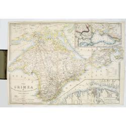
The Crimea by James Wyld Geographer to the Queen & H.R.H. Prince Albert.
The second edition of this folding map of Crimea. In the upper right corner, an inset map of the areas around the Black Sea, "The Town & Harbor of Sevastopol wit...
Place & Date: London, 1854
Selling price: $250
Sold in 2017

Nicholas I. Emperor of Russia.
Steel engraved portrait of Nicholas I (1796–1855), tsar and emperor of Russia from 1825 to 1855. Engraved by G.Cook and published by Regan Paul Trench.
Place & Date: London, ca.1855
Selling price: $10
Sold in 2020
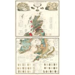
Geological and Paleaontological Map of the British Isles
Two beautiful double-page sheets combine to make one remarkable map of the British Isles. One map is titled "Geological and Paleontological Map of the British Isles,...
Place & Date: Edinburgh, 1856
Selling price: $450
Sold in 2024
![[Map puzzle] Atlas géographique.](/uploads/cache/16637-250x250.jpg)
[Map puzzle] Atlas géographique.
A uncommon geographic Jigsaw puzzle. With a double hemisphere world map, Europe and France. The maps used for the puzzle are geographically sophisticated and well engrave...
Place & Date: Paris 1860
Selling price: $295
Sold
![[ Christophe Colomb ]](/uploads/cache/21197-250x250.jpg)
[ Christophe Colomb ]
Uncommon wood block print showing Columbus and his egg.
Place & Date: France c. 1860
Selling price: $40
Sold
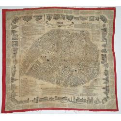
Paris - Foulard Renault, Guide dans Paris / Renault\'s illustrated Paris Guide.
Plan of Paris printed on textile. Surrounded with text and numerous vignettes.
Place & Date: Rouen, ca. 1860
Selling price: $295
Sold in 2008

Vedute dei principali monumenti di Venezia.
Decorative title page with in the lower part small inset view of Doge Palace, St. Marco and a gondola.
Place & Date: Venice, Eugenio Testolini, ca 1860
Selling price: $60
Sold in 2011

(Title page) Vedute di Venezia.
Title page with a virgin and the lion of saint Mark sitting on an island with in the background the town of Venice. Lithography by Lefevre after G.B. Cecchini.
Place & Date: Venice, ca 1860
Selling price: $49
Sold in 2022
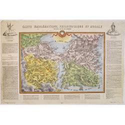
Carte emblématique, philosophique et morale ou Théatre de la vie humaine.
Rare and curious allegorical map, lithographed by G. Lyon Marmorat. The map is surrounded by an explanatory text defining the various terms such as "Empire of Satan&...
Place & Date: Lyon, ca. 1860
Selling price: $2200
Sold in 2012
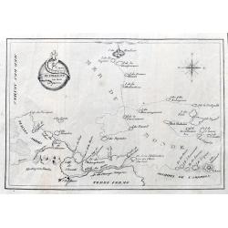
Carte du Voyage Sur la Mer du Monde.
A scarce lithographed map of the Mer Du Monde, showing the track of life with many funny place names in French, such as Ile du Travail, Detroit des etudes, Ile des Desirs...
Place & Date: Paris? ca 1860
Selling price: $100
Sold in 2021
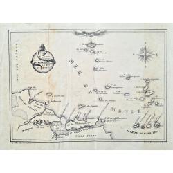
Carte du voyage sur la mer du monde
Curious humorous map in French, showing curious islands in the "Sea of the World" such as: Island of work, Island of desires, Island of greed, Island of injusti...
Place & Date: Lille, ca. 1860
Selling price: $110
Sold in 2023
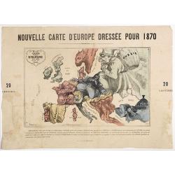
Nouvelle Carte d'Europe dressée pour 1870 / Carte drôlatique d'Europe pour 1870 dressée par Hadol.
Satirical illustration by Paul Hadol showing disposition of power in Europe at the beginning of 1870. Satirical print depicting a map of Europe in which the countries are...
Place & Date: Paris, Imprimerie Vallée, 1870
Selling price: $900
Sold
![[Interior with wallmap.]](/uploads/cache/25617-250x250.jpg)
[Interior with wallmap.]
Scene of a painter and his model set in an old Dutch interior with a wall map of Holland in the back. Etching by Willem Unger after a painting by Joannes Vermeer.Many sev...
Place & Date: Amsterdam, c. 1870
Selling price: $160
Sold in 2008
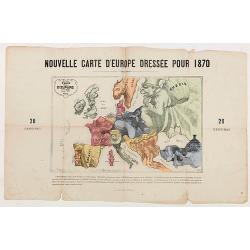
Nouvelle Carte d'Europe dressée pour 1870.
The Franco-Prussian War and The Commune in Caricature 1870-71.Satirical illustration by Paul Hadol showing disposition of power in Europe at the beginning of 1870. Satiri...
Place & Date: Paris, 1870
Selling price: $250
Sold in 2020
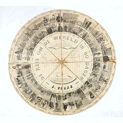
Jules Verne - Board game - Around the world in 80 days - 1877
Very rare Dutch board game - no other copies known, to the "Around the world in 80 days" by Jules Verne, published in The Netherlands in 1877. No examples in Du...
Place & Date: Netherlands, 1877
Selling price: $1075
Sold in 2016
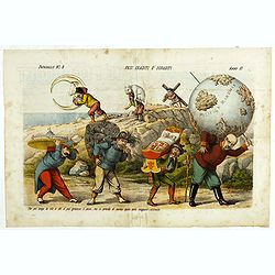
Pesi Graditi ee sgraditi. Papagallo No. 6. Anno VI.
Translation of the legend: "Several weights, each one has to carry its weight, the more serious it is, the longer the trip seems to be, and they will come sooner or ...
Place & Date: Bologne, 1878
Selling price: $300
Sold in 2024
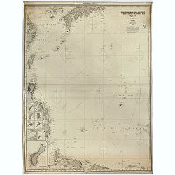
Western Pacific (Chart n°4), 1877 ( Ink stamp Imray and son London 1878)
Printed in lithography and pasted on blue paper. Generally very good condition. Published by Imray, 89 & 102 Minories, London 1864. In the upper margin, "Western...
Place & Date: London, 1864,1877, 1878
Selling price: $650
Sold in 2023
![[Map puzzle] Atlas.](/uploads/cache/16638-250x250.jpg)
[Map puzzle] Atlas.
A uncommon geographic Jigsaw puzzle. With a double hemisphere world map, Europe and France. The maps used for the puzzle are geographically sophisticated and well engrave...
Place & Date: Paris 1880
Selling price: $100
Sold
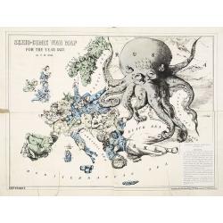
Serio-Comic War Map For The Year 1877.
Fascinating political caricature map by Frederick Rose, printed by G. W. Bacon & Co., a bygone U.K. publisher of maps and atlases, of the countries of Europe, known a...
Place & Date: London, 1877-1880
Selling price: $800
Sold in 2009
![Zoological Geography.. Birds of Europe [and] over the World. Phytology & Zoology No. 6.](/uploads/cache/1152772-250x250.jpg)
Zoological Geography.. Birds of Europe [and] over the World. Phytology & Zoology No. 6.
Original double-page engraved map (overall 55 x 66 cm.), with light original hand-coloring. As issued in The Physical Atlas... by Alexander Keth Johnstone... based on the...
Place & Date: Edinburgh, Glasgow, ca. 1880
Selling price: $130
Sold in 2020

La France. Nouvel Atlas illustré des départements et des colonies..
Uncommon and decorative title page in typical neo-gothic style. In bottom a globe and map of France. Engraved by Dyonnet.
Place & Date: Paris, 1881
Selling price: $20
Sold

Captain James Cook portrait with facsimile signature
'CAPTAIN JAMES COOK' with a facsimile signature. Exceptional engraved portrait of a fine naval man.Original steel engraving by Henry Bryan Hall, and his three sons; Henry...
Place & Date: New York, ca. 1886
Selling price: $95
Sold in 2016
Mer de Chine. Golfe du Tonkin. Entrées de Kuaï-Chin-Mun et Tsieng-Mun. . .
Large chart centred on the Gulf of Tonkin in the South China Sea. Showing banks, isles and soundings made in metres. Relief is shown by hachures.Engraved by A. Gérin aft...
Place & Date: Paris, 1887
Selling price: $300
Sold in 2008
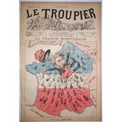
LA FRANCE ELECTORALE.
History seems really to repeat itself !? A chromolithographed satyrical map, on the ousting by election of the French populist Politician, Minister of War and Member of P...
Place & Date: Paris, 1889
Selling price: $300
Sold in 2020
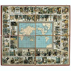
Goose game board inspired by Jules Verne's novel Tour du Monde en 80 jours.
Goose game board inspired by Jules Verne's novel whose boxes are illustrated with color lithographs and the center occupied by a world map. Vignette illustrations numbere...
Place & Date: Paris, ca. 1880-1890
Selling price: $750
Sold in 2021

El Giro del Mondo.
Goos-game with 80 numbered anticlockwise boxes, showing a journey around the world. In center a steam ship and title. I four corners the rules of the game.In box 56 the P...
Place & Date: Milan, Stab. A.Bertarelli & C., 1890
Selling price: $110
Sold in 2020
La quadratura nel circolo ossia il giuoco delle alleanze.
Circular game of alliances in Europe depicting 18 European countries personified by characters in costume and in the center, St Peter's Square in Rome. Text in 2 columns ...
Place & Date: Turino, ca. 1892
Selling price: $140
Sold in 2020
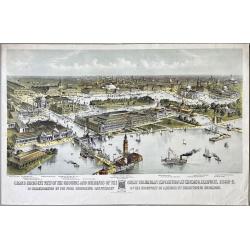
Grand Birds-Eye View of the Grounds and Buildings of the Great Columbian Exposition at Chicago, Illinois, 1892-3.
Lithography after a watercolor by C. Graham created as part of a portfolio for the World's Columbian Exposition (also known as the Chicago World's Fair) was a world's fai...
Place & Date: New York, 1892
Selling price: $1200
Sold in 2023
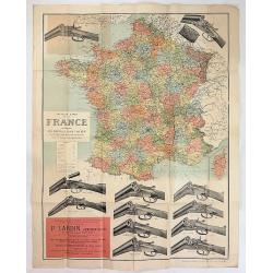
Nouvelle Carte de la France Indiquant les Routes, les Chins de Fer les Stations Thermales et Balneaires D'Apres les Documents les Plus Recents
A fascinating large map of France with the advertising of Browning shotguns. It was produced in Paris ca. 1900. Twelve shotguns are featured with their prices at the time...
Place & Date: Paris ca. 1900
Selling price: $130
Sold in 2017
Reise um die Welt in achtzig Tagen. Nach dem Roman von J. Verne. Ein unterhaltendes Gesellschaftsspiel.
Travel around the world in eighty days. After the novel by Jules Verne. An entertaining dice game with 80 fields, in the middle a world map. Title after the tutorial. Nei...
Place & Date: Germany, ca. 1900
Selling price: $1100
Sold in 2022

Face or Fortune Know Thy Self.
A most unusual item. A volvelle from Woodbury [Facial] Soap Face or Fortune - Know Thy Self with an astrological volvelle & dial on the reverse. Complete with 16 pp s...
Place & Date: New York ca 1900
Selling price: $200
Sold in 2022
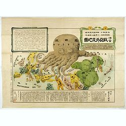
A Humorous Diplomatic Atlas of Europe and Asia. / 滑稽欧亜外交地図 / Kokkei O-A Gaiko Chizu.
A wonderful example of the rare 1904 Kisaburo Ohara satirical 'Octopus Map' of Europe. Composed at the outbreak of the Russo-Japanese War (1904 – 1905), it was modelled...
Place & Date: Tokyo, March, 1904
Selling price: $5000
Sold
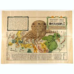
A Humorous Diplomatic Atlas of Europe and Asia. / 滑稽欧亜外交地図 / Kokkei Ō-A Gaikō Chizu.
A wonderful example of the rare 1904 Kisaburo Ohara satirical 'Octopus Map' of Europe being swallowed by an octopus (Russia). Composed at the outbreak of the Russo-Japane...
Place & Date: Tokyo, April, 1904
Selling price: $4750
Sold in 2023
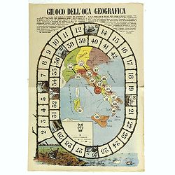
Giuoco Dell'Oca Geografica.
An attractive and rare playing board for a “Goose game” designed to teach the geographical places of Italy.The Game of the Goose is a race game wherein players move t...
Place & Date: Italy, ca. 1910
Selling price: $160
Sold in 2018
Atlas Geographique. (Cover of a Puzzle).
A separate front board of the presentation case of a geographical jigsaw puzzle. The front board is a fine example of period design, with five beauties respectively symbo...
Place & Date: Paris, ca. 1910
Selling price: $50
Sold in 2021
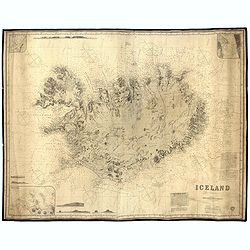
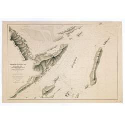
Iceland - Chart No. 114.
Very rare and large English nautical chart, consisting of two pages, compiled by James Imray. The bottom right the map has the title and pasted information about the 'Sou...
Place & Date: Londen, 1910
Selling price: $600
Sold in 2023
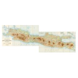
Overzichtskaart van Java en Madoera schaal 1:500.000. Met aanduiding van de politieke indeeling, de organisatie van het bestuur, de bestaande en nog aan te leggen verkeerswegen en van de groote cultuur- en industrieele centra. Samengesteld op last va
If assembled a very large color-printed map (60x 218cm.) of Java and Madoera (Madura Island) on four sheets, each measuring 60 x 54.5 cm, dissected into 12 sections and l...
Place & Date: Atelier Kurkdjian-Soerabaia, 1912
Selling price: $470
Sold in 2023
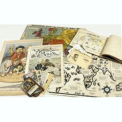
An interesting lot of World War I propaganda including some cartoons with map topics.
A group of War Maps & Propaganda items, including magazine titles, post cards, propaganda, etc. Humoristische Karte von Europa im Jahre 1914 " by Lehmann-Dumont,...
Place & Date: Japan, Germany, Austria, 1898 - 1914
Selling price: $2000
Sold in 2017
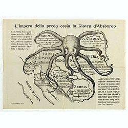
L'Impero della preda ossia la Piovra d'Absburgo.
Rare anti-German propaganda printed in occasion of the entry into the war of Italy during the first World War. The Empire Austro-Hungarian is depicted as an octopus that ...
Place & Date: Milan, ca.1915
Selling price: $960
Sold in 2019
![[Flag] Honor a los vaientes viva Espana.](/uploads/cache/23562-250x250.jpg)
[Flag] Honor a los vaientes viva Espana.
Place & Date: Spain, c.1920
Selling price: $200
Sold
![[6 Post cards of young woman seated on a globe ]](/uploads/cache/41502-250x250.jpg)
[6 Post cards of young woman seated on a globe ]
Complete set of 6 pictorial post cards showing young women seated on a globe. Signed "Morin". Unsent.More aboutcartographical curiosities [+]
Place & Date: Italy, ca. 1920
Selling price: $130
Sold in 2018
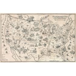
Bootlegger's Map of the United States
This awe-inspiring pictorial map was originally published in the Washington Post by a staff cartoonist Edward Gerstell McCandlish (1887 - 1946) who at the time was known ...
Place & Date: Detroit, 1926
Selling price: $800
Sold in 2023
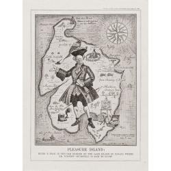
Pleasure Island.
Pleasure Island: Being A Plan in the Old Manner of the Lake Island in Canada which Mr Winston Churchill is said to covert.From Punch, September 11th 1929. An amusing map ...
Place & Date: London, 1929
Selling price: $55
Sold in 2012
Pleasure Island.
Pleasure Island: Being A Plan in the Old Manner of the Lake Island in Canada which Mr Winston Churchill is said to covert.
Place & Date: London, 1929
Selling price: $50
Sold in 2017

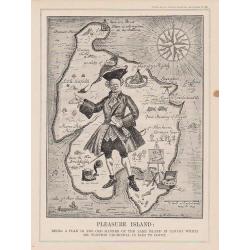
Pleasure Island : Being A Plan in the Old Manner of the Lake Island in Canada which Mr Winston Churchill is said to covert.
From Punch, September 11th, 1929.A satirical map attacking Churchill in his "Wilderness Years." In May of 1929, the Conservative government failed to gain reele...
Place & Date: London, 1929
Selling price: $75
Sold in 2019
![Le voyage du missionnaire. [board game]](/uploads/cache/37521-250x250.jpg)
Le voyage du missionnaire. [board game]
A Goose game board with in four corner missionary scenes in the four continents and in center "N°. 60 Arrivée à la Mission florisante", with Asians people he...
Place & Date: Vanves (France), ca. 1930
Selling price: $200
Sold in 2019
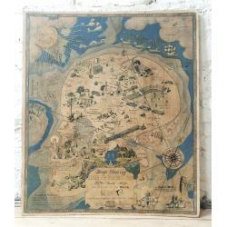
Map Showing Isle of Pleasure
An original example of a rare and humorous Prohibition-era pictorial map that illustrates the many vices that lay within the "Isle of Pleasure." The isle itself...
Place & Date: Texas, 1931
Selling price: $800
Sold in 2024
The Stock Exchange London 1933.
A beautiful and whimsical map, chock full of delightful small caricature vignettes, humorously depicting the 'goings on' in the financial market in London's City of Londo...
Place & Date: London=, 1933
Selling price: $2000
Sold in 2022
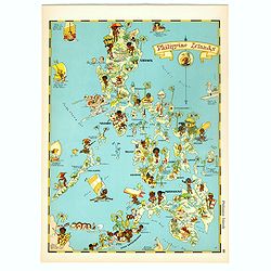
Philippines Islands.
Pictorial map of Philippines Islands, from the famous illustrator, Ruth Taylor White and published in "Our USA: A Gay Geography".Ruth Taylor White was among the...
Place & Date: Boston, Little, Brown and Company, 1935
Selling price: $250
Sold in 2018
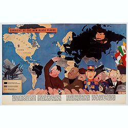
Carriers of the New Black Plague.
A powerful satirical commentary on totalitarian control of speech from the first issue of Ken Magazine. "Caught here in all their peculiar beauty by the soul searchi...
Place & Date: USA, 1938
Selling price: $70
Sold in 2021

L'Intesa Cordiale.
Cover for an Italian caricature book cover, from 1940 by Enrico Gianeri (Gec). "Gec L’INTESA CORDIALE". Signed and dated on the stone lower right.
Place & Date: Milan, 1940
Selling price: $20
Sold in 2020
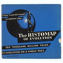
The Histomap of Evolution.
To make evolution more easy to understand, and facilitate a life to students - John B. Sparks, who created the Histomap of religion and Histomap of world history, also cr...
Place & Date: Chicago, 1942
Selling price: $310
Sold in 2018